|
|
|
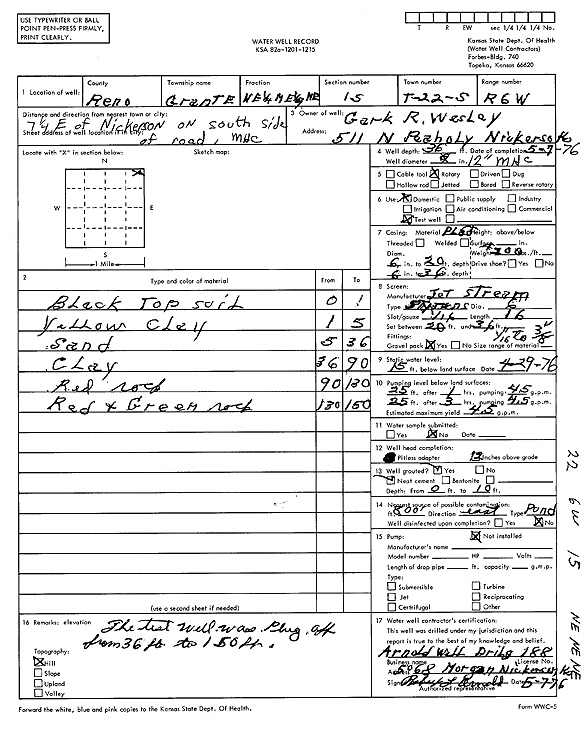
Specific Water Well Detail |
|
|
| Location Info | |||
| Owner: Wesley, Clark R. | Status: Plugged | ||
| Location: T22S, R6W, Sec. 15, NE NE NE | County: Reno | ||
| Directions: from Nickerson: 7.25 mi E on S side of rd | |||
| Latitude: 38.1434923 | Longitude: -97.960004 | Datum NAD 27 | |
| Latitude: 38.143503 | Longitude: -97.9603343 | Datum NAD 83 | |
| Longitude and latitude calculated by Survey from township-range-section-quarter calls. Only good to within the quarter call accuracy. | |||
| View well on interactive map | |||
| General Info | ||
| Well Depth: 150 ft. | Elevation: ft. | |
| Static Water Level: 15 ft. | Est. Yield: 4 gpm. | |
| Comp. Date: 07-May-1976 | Well Use: Test hole/well | |
| DWR Applic. #: | Other ID: | |
| Driller Info | ||
| Driller: Robert Arnold Water Well Drlg | License #: 188 | |
| Scanned Form | View scan |
| Casing Info | ||
|
Casing Type:
Diam: 0 in. Casing height above land surface: in | ||
| Grout Info | ||
| Grout used: | From: 0 to 0 ft
From: 0 to 0 ft From: 0 to 0 ft | |
| Source of Possible Contamination | ||
| Source: | ||
| Direction from well: | Distance: 0 ft | |
| Lithologic Log
(Log data entered by KGS.) | ||
| From: 0 ft. to 1 ft. | black top soil | |
| From: 1 ft. to 5 ft. | yellow clay | |
| From: 5 ft. to 36 ft. | sand | |
| From: 36 ft. to 90 ft. | clay | |
| From: 90 ft. to 130 ft. | red rock | |
| From: 130 ft. to 150 ft. | red and green rock | |