|
|
|
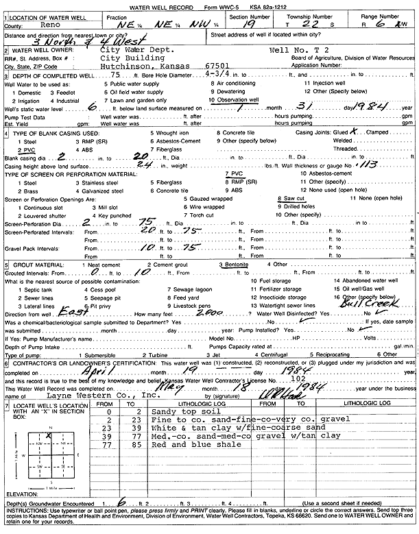
Specific Water Well Detail |
|
|
| Location Info | |||
| Owner: City of Hutchinson Water Department | Status: Constructed | ||
| Location: T22S, R6W, Sec. 19, NE NE NW | County: Reno | ||
| Directions: 3 mi N, 4 mi W | |||
| Latitude: 38.1288772 | Longitude: -98.0239925 | Datum NAD 27 | |
| Latitude: 38.1288883 | Longitude: -98.0243248 | Datum NAD 83 | |
| Longitude and latitude calculated by Survey from township-range-section-quarter calls. Only good to within the quarter call accuracy. | |||
| View well on interactive map | |||
| General Info | ||
| Well Depth: 75 ft. | Elevation: ft. | |
| Static Water Level: 6 ft. | Est. Yield: gpm. | |
| Comp. Date: 19-Apr-1984 | Well Use: Monitoring well/observation/piezometer | |
| DWR Applic. #: | Other ID: Well T2 | |
| Driller Info | ||
| Driller: Layne-Christensen Co. | License #: 102 | |
| Scanned Form | View scan |
|
Chemical Sample Submitted?: No
Water Well disinfected?: | ||
| Ground water encountered: 6 ft. , 0 ft. , 0 ft. | ||
| Pump test data: Well water was 0 ft after 0 hours pumping 0 gpm | ||
| Casing Info | ||
| Casing Type: PVC
Casing Joints: |
Diam: 2 in. to 20 ft
Diam: 0 in. to 0 ft Diam: 0 in. to 0 ft | |
| Casing height above land surface: in
Casing Weight: lbs/ft Wall thickness or gauge no.: | ||
| Screen and Perforation Info | ||
| Screen Type: PVC | Screen Openings: Saw cut | |
| Screen-perforated intervals | From: 20 ft to 75 ft
From: 0 ft to 0 ft From: 0 ft to 0 ft | |
| Gravel pack intervals | From: ft to ft | |
| Grout Info | ||
| Grout used: Bentonite | From: 0 to 10 ft
From: 0 to 0 ft From: 0 to 0 ft | |
| Source of Possible Contamination | ||
| Source: OTHER | ||
| Direction from well: | Distance: 0 ft | |
| Lithologic Log
(Log data entered by KGS.) | ||
| From: 0 ft. to 2 ft. | sandy top soil | |
| From: 2 ft. to 23 ft. | fine to coarse sand, fine-coarse-very coarse gravel | |
| From: 23 ft. to 39 ft. | white and tan clay with fine-coarse sand | |
| From: 39 ft. to 77 ft. | medium-coarse sand, medium-coarse gravel, with tan clay | |
| From: 77 ft. to 85 ft. | red and blue shale | |