|
|
|
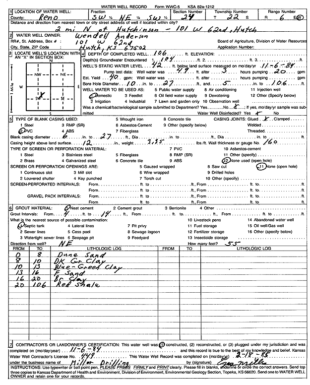
Specific Water Well Detail |
|
|
| Location Info | |||
| Owner: Anderson, Wendell | Status: Constructed | ||
| Location: T22S, R6W, Sec. 24, SW NE SW | County: Reno | ||
| Directions: 101 W 62nd, Hutchinson - from Hutchinson: 2 mi N | |||
| Latitude: 38.1195681 | Longitude: -97.934625 | Datum NAD 27 | |
| Latitude: 38.1195789 | Longitude: -97.9349547 | Datum NAD 83 | |
| Longitude and latitude calculated by Survey from township-range-section-quarter calls. Only good to within the quarter call accuracy. | |||
| View well on interactive map | |||
| General Info | ||
| Well Depth: 106 ft. | Elevation: ft. | |
| Static Water Level: 42 ft. | Est. Yield: 40 gpm. | |
| Comp. Date: 06-Nov-1984 | Well Use: Domestic | |
| DWR Applic. #: | Other ID: | |
| Driller Info | ||
| Driller: Midwest Well & Pump, Inc. | License #: 449 | |
| Scanned Form | View scan |
|
Chemical Sample Submitted?: No
Water Well disinfected?: | ||
| Ground water encountered: 104 ft. , 0 ft. , 0 ft. | ||
| Pump test data: Well water was 49 ft after 3 hours pumping 20 gpm | ||
| Casing Info | ||
| Casing Type: PVC
Casing Joints: |
Diam: 6 in. to 27 ft
Diam: 0 in. to 0 ft Diam: 0 in. to 0 ft | |
| Casing height above land surface: in
Casing Weight: lbs/ft Wall thickness or gauge no.: | ||
| Screen and Perforation Info | ||
| Screen Type: None | Screen Openings: OTHER | |
| Screen-perforated intervals | From: 0 ft to 0 ft
From: 0 ft to 0 ft From: 0 ft to 0 ft | |
| Gravel pack intervals | From: ft to ft | |
| Grout Info | ||
| Grout used: Neat cement | From: 4 to 14 ft
From: 0 to 0 ft From: 0 to 0 ft | |
| Source of Possible Contamination | ||
| Source: Septic Tank | ||
| Direction from well: | Distance: 0 ft | |
| Lithologic Log
(Log data entered by KGS.) | ||
| From: 0 ft. to 8 ft. | dune sand | |
| From: 8 ft. to 10 ft. | dark gray clay | |
| From: 10 ft. to 13 ft. | blue-green clay | |
| From: 13 ft. to 16 ft. | fine sand | |
| From: 16 ft. to 20 ft. | brown clay | |
| From: 20 ft. to 106 ft. | red shale | |