|
|
|
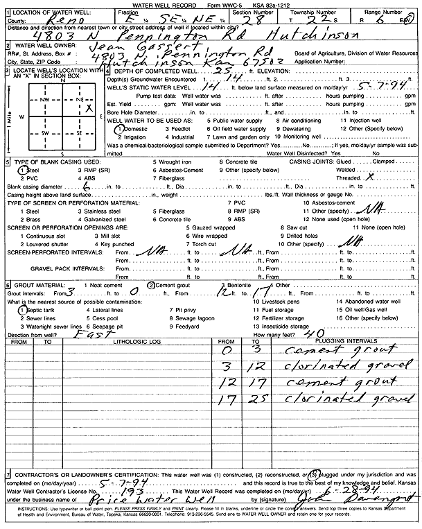
Specific Water Well Detail |
|
|
| Location Info | |||
| Owner: Gassert, Jean | Status: Plugged | ||
| Location: T22S, R6W, Sec. 28, E2 SE NE | County: Reno | ||
| Directions: 4803 N Pennington Rd, Hutchinson | |||
| Latitude: 38.1093581 | Longitude: -97.9785833 | Datum NAD 27 | |
| Latitude: 38.1093691 | Longitude: -97.9789142 | Datum NAD 83 | |
| Longitude and latitude calculated by Survey from township-range-section-quarter calls. Only good to within the quarter call accuracy. | |||
| View well on interactive map | |||
| General Info | ||
| Well Depth: 25 ft. | Elevation: ft. | |
| Static Water Level: 14 ft. | Est. Yield: gpm. | |
| Comp. Date: 07-May-1994 | Well Use: Domestic | |
| DWR Applic. #: | Other ID: | |
| Driller Info | ||
| Driller: Price Water Well Service | License #: 193 | |
| Scanned Form | View scan |
| Casing Info | ||
|
Casing Type: Steel
Diam: 6 in. Casing height above land surface: in | ||
| Grout Info | ||
| Grout used: Cement grout | From: 0 to 3 ft
From: 12 to 17 ft From: 0 to 0 ft | |
| Source of Possible Contamination | ||
| Source: Septic Tank | ||
| Direction from well: | Distance: 0 ft | |