|
|
|
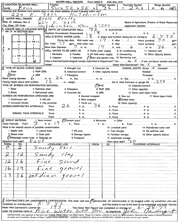
Specific Water Well Detail |
|
|
| Location Info | |||
| Owner: Astle Realty | Status: Constructed | ||
| Location: T22S, R6W, Sec. 36, SW SE SE | County: Reno | ||
| Directions: 224 E 30th | |||
| Latitude: 38.0874192 | Longitude: -97.9251514 | Datum NAD 27 | |
| Latitude: 38.0874302 | Longitude: -97.9254811 | Datum NAD 83 | |
| Longitude and latitude calculated by Survey from township-range-section-quarter calls. Only good to within the quarter call accuracy. | |||
| View well on interactive map | |||
| General Info | ||
| Well Depth: 36 ft. | Elevation: ft. | |
| Static Water Level: 18 ft. | Est. Yield: 75 gpm. | |
| Comp. Date: 09-Jun-1992 | Well Use: Domestic, Lawn and Garden | |
| DWR Applic. #: | Other ID: | |
| Driller Info | ||
| Driller: Price Water Well Service | License #: 193 | |
| Scanned Form | View scan |
|
Chemical Sample Submitted?: No
Water Well disinfected?: | ||
| Ground water encountered: 18 ft. , 0 ft. , 0 ft. | ||
| Pump test data: Well water was 19 ft after 1 hours pumping 30 gpm | ||
| Casing Info | ||
| Casing Type: PVC
Casing Joints: |
Diam: 6 in. to 26 ft
Diam: 0 in. to 0 ft Diam: 0 in. to 0 ft | |
| Casing height above land surface: in
Casing Weight: lbs/ft Wall thickness or gauge no.: | ||
| Screen and Perforation Info | ||
| Screen Type: PVC | Screen Openings: Drilled holes | |
| Screen-perforated intervals | From: 26 ft to 36 ft
From: 0 ft to 0 ft From: 0 ft to 0 ft | |
| Gravel pack intervals | From: ft to ft | |
| Grout Info | ||
| Grout used: Cement grout | From: 3 to 19 ft
From: 0 to 0 ft From: 0 to 0 ft | |
| Source of Possible Contamination | ||
| Source: Watertight sewer lines | ||
| Direction from well: | Distance: 0 ft | |
| Lithologic Log
(Log data entered by KGS.) | ||
| From: 0 ft. to 2 ft. | sandy soil | |
| From: 2 ft. to 12 ft. | sandy clay | |
| From: 12 ft. to 16 ft. | fine sand | |
| From: 16 ft. to 19 ft. | fine gravel | |
| From: 19 ft. to 36 ft. | medium gravel | |