|
|
|
Specific Water Well Detail |
|
|
| Location Info | |||
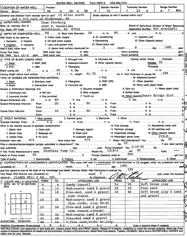
| Owner: Stroberg, Dean | Status: Constructed | ||
| Location: T22S, R7W, Sec. 23, SE SW NE | County: Reno | ||
| Directions: from Nickerson: 1.5 mi S, 1.75 mi E | |||
| Latitude: 38.1238007 | Longitude: -98.0556987 | Datum NAD 27 | |
| Latitude: 38.1238119 | Longitude: -98.0560324 | Datum NAD 83 | |
| Longitude and latitude calculated by Survey from township-range-section-quarter calls. Only good to within the quarter call accuracy. | |||
| View well on interactive map | |||
| General Info | ||
| Well Depth: 60 ft. | Elevation: ft. | |
| Static Water Level: 9 ft. | Est. Yield: gpm. | |
| Comp. Date: 09-Mar-1981 | Well Use: Irrigation | |
| DWR Applic. #: | Other ID: | |
| Links | |
| No Wizard information available. | |
| View info from WIMAS Water Right Data base... | |
| Driller Info | ||
| Driller: Clarke Well and Equipment, Inc. | License #: 185 | |
| Scanned Form | View scan |
|
Chemical Sample Submitted?: No
Water Well disinfected?: | ||
| Ground water encountered: 0 ft. , 0 ft. , 0 ft. | ||
| Pump test data: Well water was 0 ft after 0 hours pumping 0 gpm | ||
| Casing Info | ||
| Casing Type:
Casing Joints: |
Diam: 0 in. to 0 ft
Diam: 0 in. to 0 ft Diam: 0 in. to 0 ft | |
| Casing height above land surface: in
Casing Weight: lbs/ft Wall thickness or gauge no.: | ||
| Screen and Perforation Info | ||
| Screen Type: | Screen Openings: | |
| Screen-perforated intervals | From: 20 ft to 60 ft
From: 0 ft to 0 ft From: 0 ft to 0 ft | |
| Gravel pack intervals | From: ft to ft | |
| Grout Info | ||
| Grout used: | From: 0 to 0 ft
From: 0 to 0 ft From: 0 to 0 ft | |
| Source of Possible Contamination | ||
| Source: | ||
| Direction from well: | Distance: 0 ft | |
| Lithologic Log
(Log data entered by KGS.) | ||
| From: 0 ft. to 4 ft. | sandy top soil | |
| From: 4 ft. to 14 ft. | medium-coarse sand and gravel | |
| From: 14 ft. to 18 ft. | fine-medium sand and gravel, some coarse | |
| From: 18 ft. to 25 ft. | medium-coarse sand and gravel with fine streaks of clay at 20-25 feet | |
| From: 25 ft. to 39 ft. | fine-medium sand and gravel with some coarse streaks | |
| From: 39 ft. to 44 ft. | medium-coarse sand and gravel | |
| From: 44 ft. to 49 ft. | fine-medium sand and gravel | |
| From: 49 ft. to 54 ft. | very fine sand with streaks of brown clay | |
| From: 54 ft. to 56 ft. | soft brown clay | |
| From: 56 ft. to 59 ft. | fine sand | |
| From: 59 ft. to 60 ft. | soft brown clay and sand and gravel | |