|
|
|
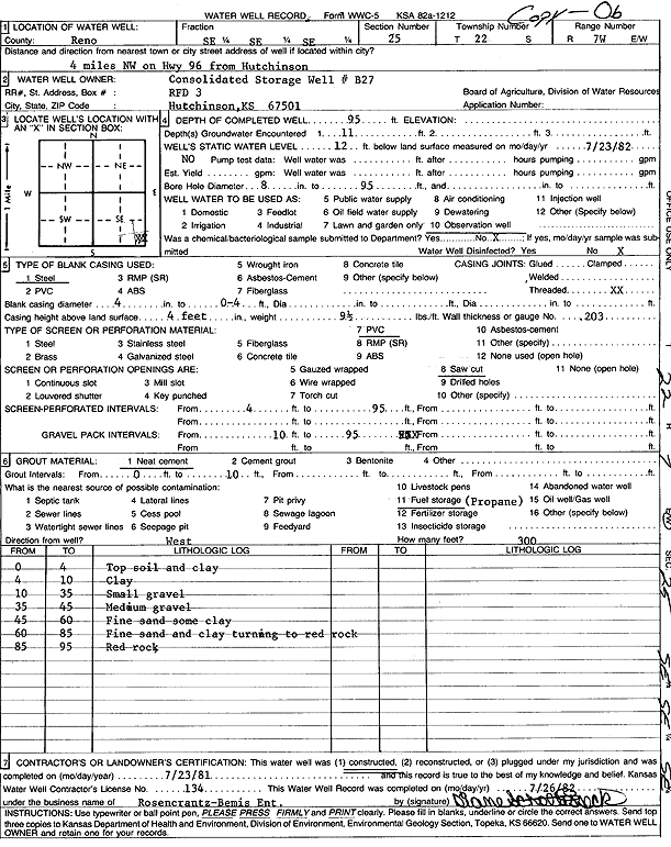
Specific Water Well Detail |
|
|
| Location Info | |||
| Owner: Consolidated Storage | Status: Constructed | ||
| Location: T22S, R7W, Sec. 25, SE SE SE | County: Reno | ||
| Directions: from Hutchinson: 4 mi NW on Hwy 96 | |||
| Latitude: 38.1015598 | Longitude: -98.0327941 | Datum NAD 27 | |
| Latitude: 38.1015711 | Longitude: -98.0331268 | Datum NAD 83 | |
| Longitude and latitude calculated by Survey from township-range-section-quarter calls. Only good to within the quarter call accuracy. | |||
| View well on interactive map | |||
| General Info | ||
| Well Depth: 95 ft. | Elevation: ft. | |
| Static Water Level: 12 ft. | Est. Yield: gpm. | |
| Comp. Date: 23-Jul-1981 | Well Use: Monitoring well/observation/piezometer | |
| DWR Applic. #: | Other ID: B 27 | |
| Driller Info | ||
| Driller: Rosencrantz-Bemis Enterprises, Inc. | License #: 134 | |
| Scanned Form | View scan |
|
Chemical Sample Submitted?: No
Water Well disinfected?: | ||
| Ground water encountered: 0 ft. , 0 ft. , 0 ft. | ||
| Pump test data: Well water was 0 ft after 0 hours pumping 0 gpm | ||
| Casing Info | ||
| Casing Type:
Casing Joints: |
Diam: 0 in. to 0 ft
Diam: 0 in. to 0 ft Diam: 0 in. to 0 ft | |
| Casing height above land surface: in
Casing Weight: lbs/ft Wall thickness or gauge no.: | ||
| Screen and Perforation Info | ||
| Screen Type: | Screen Openings: | |
| Screen-perforated intervals | From: 4 ft to 95 ft
From: 0 ft to 0 ft From: 0 ft to 0 ft | |
| Gravel pack intervals | From: ft to ft | |
| Grout Info | ||
| Grout used: | From: 0 to 0 ft
From: 0 to 0 ft From: 0 to 0 ft | |
| Source of Possible Contamination | ||
| Source: | ||
| Direction from well: | Distance: 0 ft | |
| Lithologic Log
(Log data entered by KGS.) | ||
| From: 0 ft. to 4 ft. | top soil and clay | |
| From: 4 ft. to 10 ft. | clay | |
| From: 10 ft. to 35 ft. | small gravel | |
| From: 35 ft. to 45 ft. | medium gravel | |
| From: 45 ft. to 60 ft. | fine sand with some clay | |
| From: 60 ft. to 85 ft. | fine sand and clay turning to red rock | |
| From: 85 ft. to 95 ft. | red rock | |