|
|
|
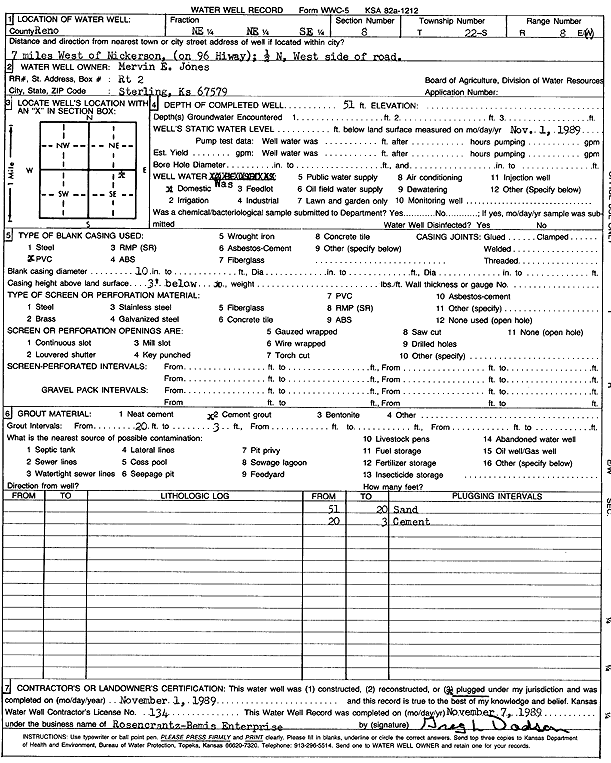
Specific Water Well Detail |
|
|
| Location Info | |||
| Owner: Jones, Mervin E. | Status: Plugged | ||
| Location: T22S, R8W, Sec. 8, NE NE SE | County: Reno | ||
| Directions: from Nickerson: 7 mi W on Hwy 96, .5 mi N, W side rd | |||
| Latitude: 38.1505462 | Longitude: -98.216736 | Datum NAD 27 | |
| Latitude: 38.150558 | Longitude: -98.2170762 | Datum NAD 83 | |
| Longitude and latitude calculated by Survey from township-range-section-quarter calls. Only good to within the quarter call accuracy. | |||
| View well on interactive map | |||
| General Info | ||
| Well Depth: 51 ft. | Elevation: ft. | |
| Static Water Level: ft. | Est. Yield: gpm. | |
| Comp. Date: 01-Nov-1989 | Well Use: Domestic | |
| DWR Applic. #: | Other ID: | |
| Driller Info | ||
| Driller: Rosencrantz-Bemis Enterprises, Inc. | License #: 134 | |
| Scanned Form | View scan |
| Casing Info | ||
|
Casing Type: PVC
Diam: 10 in. Casing height above land surface: in | ||
| Grout Info | ||
| Grout used: Cement grout | From: 3 to 20 ft
From: 0 to 0 ft From: 0 to 0 ft | |
| Source of Possible Contamination | ||
| Source: OTHER | ||
| Direction from well: | Distance: 0 ft | |