|
|
|
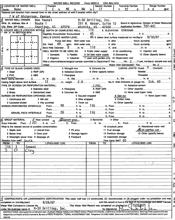
Specific Water Well Detail |
|
|
| Location Info | |||
| Owner: H-30 Drilling/Don Yeakel | Status: Plugged | ||
| Location: T22S, R8W, Sec. 17, C NE NW | County: Reno | ||
| Directions: from Nickerson: 7 mi W | |||
| Latitude: 38.1422548 | Longitude: -98.2271755 | Datum NAD 27 | |
| Latitude: 38.1422667 | Longitude: -98.2275163 | Datum NAD 83 | |
| Longitude and latitude calculated by Survey from township-range-section-quarter calls. Only good to within the quarter call accuracy. | |||
| View well on interactive map | |||
| General Info | ||
| Well Depth: 110 ft. | Elevation: ft. | |
| Static Water Level: 45 ft. | Est. Yield: 60 gpm. | |
| Comp. Date: 26-Sep-1987 | Well Use: Oil Field Water Supply | |
| DWR Applic. #: T87-441 | Other ID: | |
| Driller Info | ||
| Driller: H-30 Drilling, Inc. | License #: | |
| Scanned Form | View scan |
| Casing Info | ||
|
Casing Type: PVC
Diam: 5 in. Casing height above land surface: in | ||
| Grout Info | ||
| Grout used: Cement grout | From: 110 to 3 ft
From: 0 to 0 ft From: 0 to 0 ft | |
| Source of Possible Contamination | ||
| Source: Oil well/gas well | ||
| Direction from well: | Distance: 0 ft | |