|
|
|
Specific Water Well Detail |
|
|
| Location Info | |||
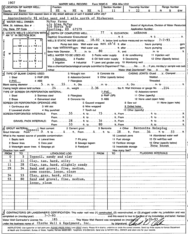
| Owner: McVay Farms | Status: Constructed | ||
| Location: T22S, R9W, Sec. 11, NE NE NE | County: Reno | ||
| Directions: from Nickerson: 9.25 mi W, 1 mi N | |||
| Latitude: 38.1581293 | Longitude: -98.271391 | Datum NAD 27 | |
| Latitude: 38.1581412 | Longitude: -98.2717334 | Datum NAD 83 | |
| Longitude and latitude calculated by Survey from township-range-section-quarter calls. Only good to within the quarter call accuracy. | |||
| View well on interactive map | |||
| General Info | ||
| Well Depth: 77 ft. | Elevation: ft. | |
| Static Water Level: 18.02 ft. | Est. Yield: gpm. | |
| Comp. Date: 07-Jul-1993 | Well Use: Domestic | |
| DWR Applic. #: | Other ID: | |
| Driller Info | ||
| Driller: Clarke Well and Equipment, Inc. | License #: 185 | |
| Scanned Form | View scan |
|
Chemical Sample Submitted?: No
Water Well disinfected?: | ||
| Ground water encountered: 0 ft. , 0 ft. , 0 ft. | ||
| Pump test data: Well water was 0 ft after 0 hours pumping 0 gpm | ||
| Casing Info | ||
| Casing Type: PVC
Casing Joints: |
Diam: 5 in. to 55 ft
Diam: 0 in. to 0 ft Diam: 0 in. to 0 ft | |
| Casing height above land surface: in
Casing Weight: lbs/ft Wall thickness or gauge no.: | ||
| Screen and Perforation Info | ||
| Screen Type: PVC | Screen Openings: Drilled holes | |
| Screen-perforated intervals | From: 55 ft to 75 ft
From: 0 ft to 0 ft From: 0 ft to 0 ft | |
| Gravel pack intervals | From: ft to ft | |
| Grout Info | ||
| Grout used: | From: 0 to 4 ft
From: 4 to 28 ft From: 34 to 53 ft | |
| Source of Possible Contamination | ||
| Source: OTHER | ||
| Direction from well: | Distance: 0 ft | |
| Lithologic Log
(Log data entered by KGS.) | ||
| From: 0 ft. to 5 ft. | sandy top soil and clay | |
| From: 5 ft. to 11 ft. | clay, tan, hard, silty | |
| From: 11 ft. to 28 ft. | clay, tan, hard, slightly sandy | |
| From: 28 ft. to 34 ft. | sand and gravel; fine, medium, some coarse, loose, clean | |
| From: 34 ft. to 53 ft. | clay, gray, hard, silty | |
| From: 53 ft. to 80 ft. | sand and gravel; fine, medium, loose, clean | |