|
|
|
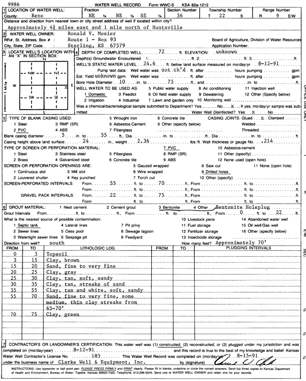
Specific Water Well Detail |
|
|
| Location Info | |||
| Owner: Mosier, Ronald V. | Status: Constructed | ||
| Location: T22S, R9W, Sec. 36, NE NE SE | County: Reno | ||
| Directions: from Huntsville: 4.25 mi E, 1 mi N | |||
| Latitude: 38.0926452 | Longitude: -98.2529238 | Datum NAD 27 | |
| Latitude: 38.0926578 | Longitude: -98.253266 | Datum NAD 83 | |
| Longitude and latitude calculated by Survey from township-range-section-quarter calls. Only good to within the quarter call accuracy. | |||
| View well on interactive map | |||
| General Info | ||
| Well Depth: 72 ft. | Elevation: ft. | |
| Static Water Level: 24.6 ft. | Est. Yield: gpm. | |
| Comp. Date: 12-Aug-1991 | Well Use: Domestic | |
| DWR Applic. #: | Other ID: | |
| Driller Info | ||
| Driller: Clarke Well and Equipment, Inc. | License #: 185 | |
| Scanned Form | View scan |
|
Chemical Sample Submitted?: No
Water Well disinfected?: | ||
| Ground water encountered: 0 ft. , 0 ft. , 0 ft. | ||
| Pump test data: Well water was 0 ft after 0 hours pumping 0 gpm | ||
| Casing Info | ||
| Casing Type: PVC
Casing Joints: |
Diam: 5 in. to 55 ft
Diam: 0 in. to 0 ft Diam: 0 in. to 0 ft | |
| Casing height above land surface: in
Casing Weight: lbs/ft Wall thickness or gauge no.: | ||
| Screen and Perforation Info | ||
| Screen Type: PVC | Screen Openings: Drilled holes | |
| Screen-perforated intervals | From: 55 ft to 70 ft
From: 0 ft to 0 ft From: 0 ft to 0 ft | |
| Gravel pack intervals | From: ft to ft | |
| Grout Info | ||
| Grout used: Bentonite | From: 0 to 20 ft
From: 0 to 0 ft From: 0 to 0 ft | |
| Source of Possible Contamination | ||
| Source: Septic Tank | ||
| Direction from well: | Distance: 0 ft | |
| Lithologic Log
(Log data entered by KGS.) | ||
| From: 0 ft. to 3 ft. | top soil | |
| From: 3 ft. to 15 ft. | clay, brown | |
| From: 15 ft. to 20 ft. | sand, fine to very fine | |
| From: 20 ft. to 25 ft. | clay, gray | |
| From: 25 ft. to 30 ft. | clay, tan, soft, sandy | |
| From: 30 ft. to 35 ft. | clay, tan, with streaks of sand | |
| From: 35 ft. to 55 ft. | clay, tan and white, soft, sandy | |
| From: 55 ft. to 70 ft. | sand, fine to very fine, some medium, with thin clay streaks from 65-70 feet | |
| From: 70 ft. to 75 ft. | clay, green | |