|
|
|
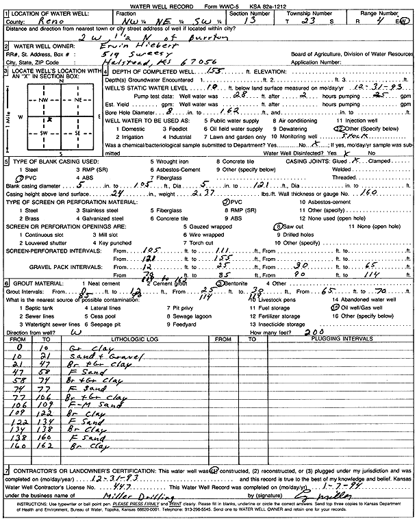
Specific Water Well Detail |
|
|
| Location Info | |||
| Owner: Hiebert, Ervin | Status: Constructed | ||
| Location: T23S, R4W, Sec. 13, NW NE SW | County: Reno | ||
| Directions: from Burrton: 2 mi W, 1.5 mi N | |||
| Latitude: 38.0494048 | Longitude: -97.714379 | Datum NAD 27 | |
| Latitude: 38.0494157 | Longitude: -97.7147033 | Datum NAD 83 | |
| Longitude and latitude calculated by Survey from township-range-section-quarter calls. Only good to within the quarter call accuracy. | |||
| View well on interactive map | |||
| General Info | ||
| Well Depth: 155 ft. | Elevation: ft. | |
| Static Water Level: 10 ft. | Est. Yield: gpm. | |
| Comp. Date: 31-Dec-1993 | Well Use: Domestic, Livestock | |
| DWR Applic. #: | Other ID: | |
| Driller Info | ||
| Driller: Miller Drilling | License #: 447 | |
| Scanned Form | View scan |
|
Chemical Sample Submitted?: No
Water Well disinfected?: | ||
| Ground water encountered: 0 ft. , 0 ft. , 0 ft. | ||
| Pump test data: Well water was 28 ft after 2 hours pumping 25 gpm | ||
| Casing Info | ||
| Casing Type: PVC
Casing Joints: |
Diam: 5 in. to 105 ft
Diam: 5 in. to 121 ft Diam: 0 in. to 0 ft | |
| Casing height above land surface: in
Casing Weight: lbs/ft Wall thickness or gauge no.: | ||
| Screen and Perforation Info | ||
| Screen Type: PVC | Screen Openings: Saw cut | |
| Screen-perforated intervals | From: 105 ft to 111 ft
From: 121 ft to 155 ft From: 0 ft to 0 ft | |
| Gravel pack intervals | From: ft to ft | |
| Grout Info | ||
| Grout used: Bentonite | From: 0 to 12 ft
From: 25 to 30 ft From: 65 to 70 ft | |
| Source of Possible Contamination | ||
| Source: Oil well/gas well | ||
| Direction from well: | Distance: 0 ft | |
| Lithologic Log
(Log data entered by KGS.) | ||
| From: 0 ft. to 10 ft. | gray clay | |
| From: 10 ft. to 21 ft. | sand and gravel | |
| From: 21 ft. to 47 ft. | brown and gray clay | |
| From: 47 ft. to 58 ft. | fine sand | |
| From: 58 ft. to 74 ft. | brown and gray clay | |
| From: 74 ft. to 77 ft. | fine sand | |
| From: 77 ft. to 106 ft. | brown and gray clay | |
| From: 106 ft. to 109 ft. | fine-medium sand | |
| From: 109 ft. to 122 ft. | brown clay | |
| From: 122 ft. to 134 ft. | fine sand | |
| From: 134 ft. to 138 ft. | brown clay | |
| From: 138 ft. to 160 ft. | fine sand | |
| From: 160 ft. to 162 ft. | brown clay | |