|
|
|
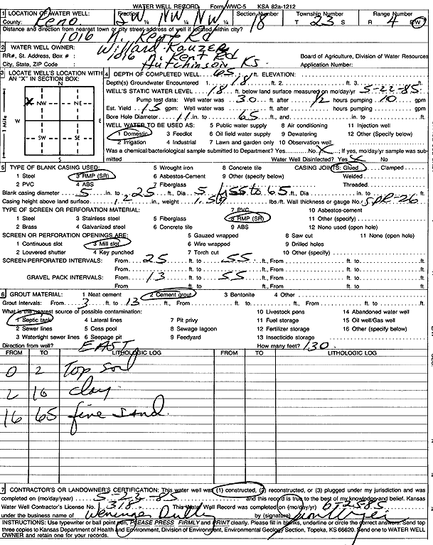
Specific Water Well Detail |
|
|
| Location Info | |||
| Owner: Kauzer, Willard | Status: Constructed | ||
| Location: T23S, R4W, Sec. 18, SW NW NW | County: Reno | ||
| Directions: 1016 N Kent Rd, Hutchinson | |||
| Latitude: 38.0546691 | Longitude: -97.8101374 | Datum NAD 27 | |
| Latitude: 38.0546802 | Longitude: -97.8104643 | Datum NAD 83 | |
| Longitude and latitude calculated by Survey from township-range-section-quarter calls. Only good to within the quarter call accuracy. | |||
| View well on interactive map | |||
| General Info | ||
| Well Depth: 65 ft. | Elevation: ft. | |
| Static Water Level: 18 ft. | Est. Yield: 15 gpm. | |
| Comp. Date: 22-May-1985 | Well Use: Domestic | |
| DWR Applic. #: | Other ID: | |
| Driller Info | ||
| Driller: Jerome Weninger Drilling, Inc. | License #: 318 | |
| Scanned Form | View scan |
|
Chemical Sample Submitted?: No
Water Well disinfected?: | ||
| Ground water encountered: 18 ft. , 0 ft. , 0 ft. | ||
| Pump test data: Well water was 30 ft after 0 hours pumping 10 gpm | ||
| Casing Info | ||
| Casing Type: RMP(SR)
Casing Joints: |
Diam: 5 in. to 25 ft
Diam: 5 in. to 65 ft Diam: 0 in. to 0 ft | |
| Casing height above land surface: in
Casing Weight: lbs/ft Wall thickness or gauge no.: | ||
| Screen and Perforation Info | ||
| Screen Type: RMP (SR) | Screen Openings: Mill slot | |
| Screen-perforated intervals | From: 25 ft to 55 ft
From: 0 ft to 0 ft From: 0 ft to 0 ft | |
| Gravel pack intervals | From: ft to ft | |
| Grout Info | ||
| Grout used: Cement grout | From: 3 to 13 ft
From: 0 to 0 ft From: 0 to 0 ft | |
| Source of Possible Contamination | ||
| Source: Septic Tank | ||
| Direction from well: | Distance: 0 ft | |
| Lithologic Log
(Log data entered by KGS.) | ||
| From: 0 ft. to 2 ft. | top soil | |
| From: 2 ft. to 16 ft. | clay | |
| From: 16 ft. to 65 ft. | fine sand | |