|
|
|
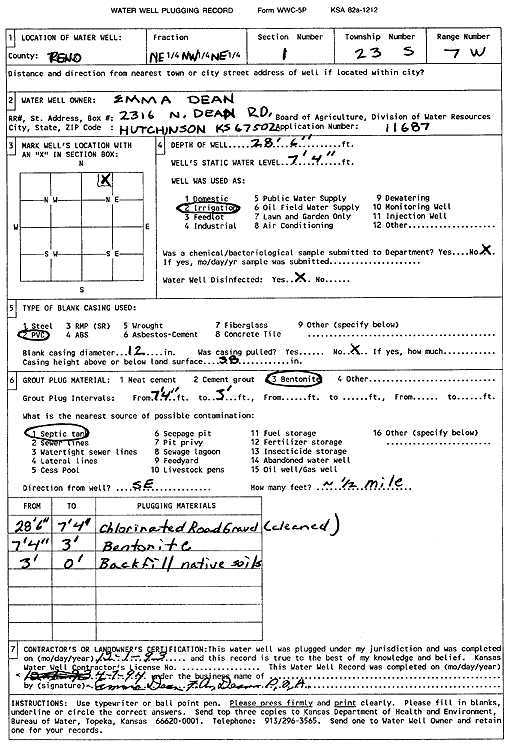
Specific Water Well Detail |
|
|
| Location Info | |||
| Owner: Dean, Emma | Status: Plugged | ||
| Location: T23S, R7W, Sec. 1, NE NW NE | County: Reno | ||
| Directions: | |||
| Latitude: 38.0852986 | Longitude: -98.0373517 | Datum NAD 27 | |
| Latitude: 38.08531 | Longitude: -98.0376848 | Datum NAD 83 | |
| Longitude and latitude calculated by Survey from township-range-section-quarter calls. Only good to within the quarter call accuracy. | |||
| View well on interactive map | |||
| General Info | ||
| Well Depth: 28.5 ft. | Elevation: ft. | |
| Static Water Level: 7.33 ft. | Est. Yield: gpm. | |
| Comp. Date: 01-Dec-1993 | Well Use: Irrigation | |
| DWR Applic. #: 11687 | Other ID: | |
| Links | |
| View info from Wizard Water Level Data base... | |
| View info from WIMAS Water Right Data base... | |
| Driller Info | ||
| Driller: Emma Dean, F.A. Dean | License #: | |
| Scanned Form | View scan |
| Casing Info | ||
|
Casing Type: PVC
Diam: 12 in. Casing height above land surface: in | ||
| Grout Info | ||
| Grout used: Bentonite | From: 3 to 7 ft
From: 0 to 0 ft From: 0 to 0 ft | |
| Source of Possible Contamination | ||
| Source: Septic Tank | ||
| Direction from well: | Distance: 0 ft | |