|
|
|
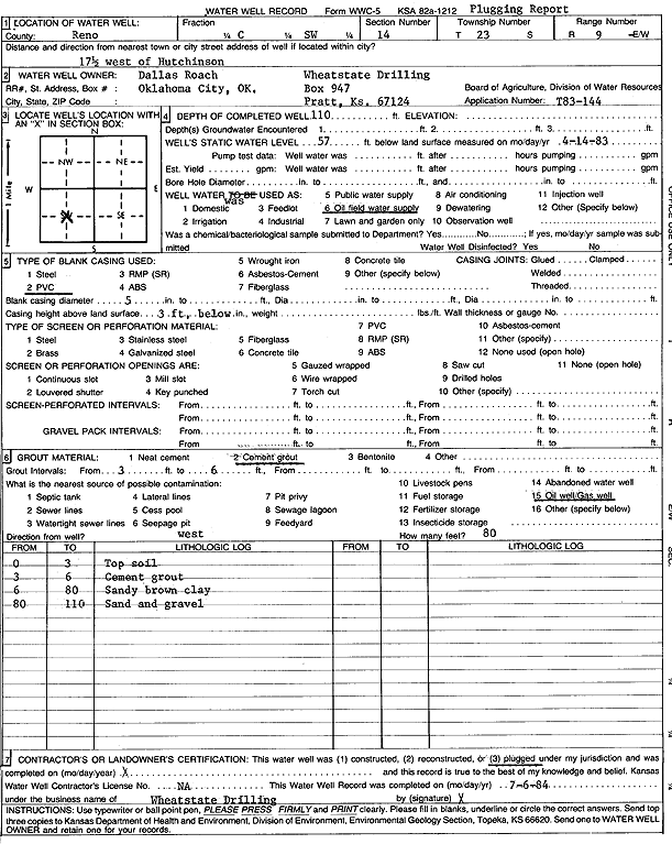
Specific Water Well Detail |
|
|
| Location Info | |||
| Owner: Roach, Dallas/Wheatstate Drilling | Status: Plugged | ||
| Location: T23S, R9W, Sec. 14, C SW | County: Reno | ||
| Directions: from Hutchinson: 17.5 mi W | |||
| Latitude: 38.0464751 | Longitude: -98.28413 | Datum NAD 27 | |
| Latitude: 38.0464883 | Longitude: -98.284474 | Datum NAD 83 | |
| Longitude and latitude calculated by Survey from township-range-section-quarter calls. Only good to within the quarter call accuracy. | |||
| View well on interactive map | |||
| General Info | ||
| Well Depth: 110 ft. | Elevation: ft. | |
| Static Water Level: 57 ft. | Est. Yield: gpm. | |
| Comp. Date: 14-Apr-1983 | Well Use: Oil Field Water Supply | |
| DWR Applic. #: T83-144 | Other ID: | |
| Driller Info | ||
| Driller: Wheatstate Drilling | License #: | |
| Scanned Form | View scan |
| Casing Info | ||
|
Casing Type: PVC
Diam: 5 in. Casing height above land surface: in | ||
| Grout Info | ||
| Grout used: Cement grout | From: 3 to 6 ft
From: 0 to 0 ft From: 0 to 0 ft | |
| Source of Possible Contamination | ||
| Source: Oil well/gas well | ||
| Direction from well: | Distance: 0 ft | |