|
|
|
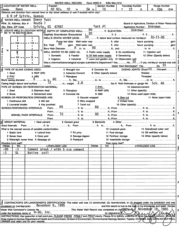
Specific Water Well Detail |
|
|
| Location Info | |||
| Owner: Yust, Emery | Status: Plugged | ||
| Location: T23S, R10W, Sec. 15, N2 N2 SW | County: Reno | ||
| Directions: from Sylvia: 6 mi N | |||
| Latitude: 38.0486301 | Longitude: -98.4128899 | Datum NAD 27 | |
| Latitude: 38.0486438 | Longitude: -98.41324 | Datum NAD 83 | |
| Longitude and latitude calculated by Survey from township-range-section-quarter calls. Only good to within the quarter call accuracy. | |||
| View well on interactive map | |||
| General Info | ||
| Well Depth: 80 ft. | Elevation: ft. | |
| Static Water Level: 20 ft. | Est. Yield: 60 gpm. | |
| Comp. Date: 08-Nov-1985 | Well Use: Oil Field Water Supply | |
| DWR Applic. #: | Other ID: Yust 1 | |
| Driller Info | ||
| Driller: H-30, Inc. | License #: | |
| Scanned Form | View scan |
| Casing Info | ||
|
Casing Type: PVC
Diam: 5 in. Casing height above land surface: in | ||
| Grout Info | ||
| Grout used: | From: 0 to 0 ft
From: 0 to 0 ft From: 0 to 0 ft | |
| Source of Possible Contamination | ||
| Source: | ||
| Direction from well: | Distance: 0 ft | |