|
|
|
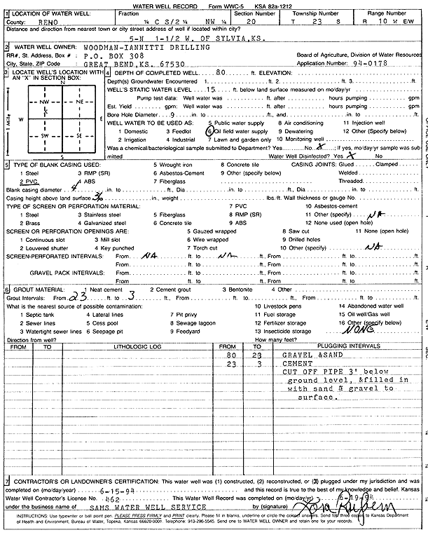
Specific Water Well Detail |
|
|
| Location Info | |||
| Owner: Woodman-Iannitti Drilling Co. | Status: Plugged | ||
| Location: T23S, R10W, Sec. 20, C S2 NW | County: Reno | ||
| Directions: from Sylvia: 5 mi N, 1.5 mi W | |||
| Latitude: 38.0368484 | Longitude: -98.4494436 | Datum NAD 27 | |
| Latitude: 38.0368624 | Longitude: -98.4497956 | Datum NAD 83 | |
| Longitude and latitude calculated by Survey from township-range-section-quarter calls. Only good to within the quarter call accuracy. | |||
| View well on interactive map | |||
| General Info | ||
| Well Depth: 80 ft. | Elevation: ft. | |
| Static Water Level: 15 ft. | Est. Yield: gpm. | |
| Comp. Date: 15-Jun-1994 | Well Use: Oil Field Water Supply | |
| DWR Applic. #: 94-0178 | Other ID: | |
| Links | |
| No Wizard information available. | |
| View info from WIMAS Water Right Data base... | |
| Driller Info | ||
| Driller: Sam's Water Well Service | License #: 462 | |
| Scanned Form | View scan |
| Casing Info | ||
|
Casing Type: PVC
Diam: 4 in. Casing height above land surface: in | ||
| Grout Info | ||
| Grout used: Cement grout | From: 3 to 23 ft
From: 0 to 0 ft From: 0 to 0 ft | |
| Source of Possible Contamination | ||
| Source: OTHER | ||
| Direction from well: | Distance: 0 ft | |