|
|
|
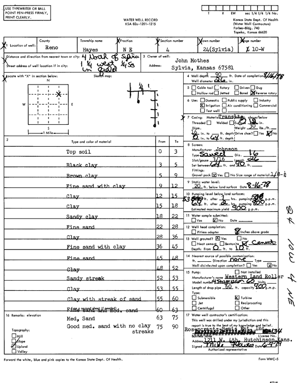
Specific Water Well Detail |
|
|
| Location Info | |||
| Owner: Mothes, John | Status: Constructed | ||
| Location: T24S, R10W, Sec. 4, NE | County: Reno | ||
| Directions: from Sylvia: 4 mi N, 1.25 mi W, .25 mi S into field | |||
| Latitude: 37.9952124 | Longitude: -98.4216758 | Datum NAD 27 | |
| Latitude: 37.9952267 | Longitude: -98.4220267 | Datum NAD 83 | |
| Longitude and latitude calculated by Survey from township-range-section-quarter calls. Only good to within the quarter call accuracy. | |||
| View well on interactive map | |||
| General Info | ||
| Well Depth: 90 ft. | Elevation: ft. | |
| Static Water Level: 20 ft. | Est. Yield: 900 gpm. | |
| Comp. Date: 16-Aug-1978 | Well Use: Irrigation | |
| DWR Applic. #: | Other ID: | |
| Links | |
| View info from Wizard Water Level Data base... | |
| View info from WIMAS Water Right Data base... | |
| Driller Info | ||
| Driller: Rosencrantz-Bemis Enterprises, Inc. | License #: 134 | |
| Scanned Form | View scan |
|
Chemical Sample Submitted?: No
Water Well disinfected?: | ||
| Ground water encountered: 0 ft. , 0 ft. , 0 ft. | ||
| Pump test data: Well water was 0 ft after 0 hours pumping 0 gpm | ||
| Casing Info | ||
| Casing Type:
Casing Joints: |
Diam: 0 in. to 0 ft
Diam: 0 in. to 0 ft Diam: 0 in. to 0 ft | |
| Casing height above land surface: in
Casing Weight: lbs/ft Wall thickness or gauge no.: | ||
| Screen and Perforation Info | ||
| Screen Type: | Screen Openings: | |
| Screen-perforated intervals | From: 64 ft to 90 ft
From: 0 ft to 0 ft From: 0 ft to 0 ft | |
| Gravel pack intervals | From: ft to ft | |
| Grout Info | ||
| Grout used: | From: 0 to 0 ft
From: 0 to 0 ft From: 0 to 0 ft | |
| Source of Possible Contamination | ||
| Source: | ||
| Direction from well: | Distance: 0 ft | |
| Lithologic Log
(Log data entered by KGS.) | ||
| From: 0 ft. to 3 ft. | top soil | |
| From: 3 ft. to 5 ft. | black clay | |
| From: 5 ft. to 9 ft. | brown clay | |
| From: 9 ft. to 12 ft. | fine sand with clay | |
| From: 12 ft. to 15 ft. | clay | |
| From: 15 ft. to 18 ft. | clay | |
| From: 18 ft. to 22 ft. | sandy clay | |
| From: 22 ft. to 28 ft. | fine sand | |
| From: 28 ft. to 36 ft. | clay | |
| From: 36 ft. to 45 ft. | fine sand with clay | |
| From: 45 ft. to 48 ft. | fine sand | |
| From: 48 ft. to 52 ft. | clay | |
| From: 52 ft. to 53 ft. | sandy streak | |
| From: 53 ft. to 55 ft. | clay | |
| From: 55 ft. to 60 ft. | clay with streak of sand | |
| From: 60 ft. to 63 ft. | fine and medium sand | |
| From: 63 ft. to 75 ft. | medium sand | |
| From: 75 ft. to 90 ft. | good medium sand with no clay streaks | |