|
|
|
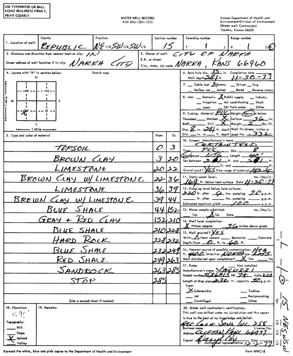
Specific Water Well Detail |
|
|
| Location Info | |||
| Owner: City of Narka | Status: Constructed | ||
| Location: T1S, R1W, Sec. 15, NE SW SW | County: Republic | ||
| Directions: | |||
| Latitude: 39.961201 | Longitude: -97.421779 | Datum NAD 27 | |
| Latitude: 39.9612056 | Longitude: -97.4220966 | Datum NAD 83 | |
| Longitude and latitude calculated by Survey from township-range-section-quarter calls. Only good to within the quarter call accuracy. | |||
| View well on interactive map | |||
| General Info | ||
| Well Depth: 281 ft. | Elevation: ft. | |
| Static Water Level: 169 ft. | Est. Yield: 100 gpm. | |
| Comp. Date: 30-Nov-1977 | Well Use: Public Water Supply | |
| DWR Applic. #: | Other ID: | |
| Links | |
| No Wizard information available. | |
| View info from WIMAS Water Right Data base... | |
| Driller Info | ||
| Driller: Geo Cox & Sons, Inc. | License #: 258 | |
| Scanned Form | View scan |
|
Chemical Sample Submitted?: No
Water Well disinfected?: | ||
| Ground water encountered: 0 ft. , 0 ft. , 0 ft. | ||
| Pump test data: Well water was 0 ft after 0 hours pumping 0 gpm | ||
| Casing Info | ||
| Casing Type:
Casing Joints: |
Diam: 0 in. to 0 ft
Diam: 0 in. to 0 ft Diam: 0 in. to 0 ft | |
| Casing height above land surface: in
Casing Weight: lbs/ft Wall thickness or gauge no.: | ||
| Screen and Perforation Info | ||
| Screen Type: | Screen Openings: | |
| Screen-perforated intervals | From: 261 ft to 281 ft
From: 0 ft to 0 ft From: 0 ft to 0 ft | |
| Gravel pack intervals | From: ft to ft | |
| Grout Info | ||
| Grout used: | From: 0 to 0 ft
From: 0 to 0 ft From: 0 to 0 ft | |
| Source of Possible Contamination | ||
| Source: | ||
| Direction from well: | Distance: 0 ft | |
| Lithologic Log
(Log data entered by KGS.) | ||
| From: 0 ft. to 3 ft. | top soil | |
| From: 3 ft. to 20 ft. | brown clay | |
| From: 20 ft. to 22 ft. | limestone | |
| From: 22 ft. to 36 ft. | brown clay with limestone | |
| From: 36 ft. to 39 ft. | limestone | |
| From: 39 ft. to 44 ft. | brown clay with limestone | |
| From: 44 ft. to 152 ft. | blue shale | |
| From: 152 ft. to 210 ft. | gray and red clay | |
| From: 210 ft. to 228 ft. | blue shale | |
| From: 228 ft. to 232 ft. | hard rock | |
| From: 232 ft. to 249 ft. | blue shale | |
| From: 249 ft. to 263 ft. | red shale | |
| From: 263 ft. to 285 ft. | sand rock | |