|
|
|
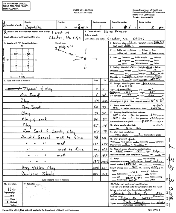
Specific Water Well Detail |
|
|
| Location Info | |||
| Owner: Fraley, Keith | Status: Constructed | ||
| Location: T1S, R3W, Sec. 3, C NE | County: Republic | ||
| Directions: from Chester, NE, 1 mi W and 0.25 mi S | |||
| Latitude: 39.9982863 | Longitude: -97.6359051 | Datum NAD 27 | |
| Latitude: 39.9982944 | Longitude: -97.6362251 | Datum NAD 83 | |
| Longitude and latitude calculated by Survey from township-range-section-quarter calls. Only good to within the quarter call accuracy. | |||
| View well on interactive map | |||
| General Info | ||
| Well Depth: 204 ft. | Elevation: ft. | |
| Static Water Level: 155 ft. | Est. Yield: 4000 gpm. | |
| Comp. Date: 11-Mar-1976 | Well Use: Irrigation | |
| DWR Applic. #: | Other ID: | |
| Links | |
| No Wizard information available. | |
| View info from WIMAS Water Right Data base... | |
| Driller Info | ||
| Driller: Dale Shuck Drilling Co. | License #: 272 | |
| Scanned Form | View scan |
|
Chemical Sample Submitted?: No
Water Well disinfected?: | ||
| Ground water encountered: 0 ft. , 0 ft. , 0 ft. | ||
| Pump test data: Well water was 0 ft after 0 hours pumping 0 gpm | ||
| Casing Info | ||
| Casing Type:
Casing Joints: |
Diam: 0 in. to 0 ft
Diam: 0 in. to 0 ft Diam: 0 in. to 0 ft | |
| Casing height above land surface: in
Casing Weight: lbs/ft Wall thickness or gauge no.: | ||
| Screen and Perforation Info | ||
| Screen Type: | Screen Openings: | |
| Screen-perforated intervals | From: 139 ft to 204 ft
From: 0 ft to 0 ft From: 0 ft to 0 ft | |
| Gravel pack intervals | From: ft to ft | |
| Grout Info | ||
| Grout used: | From: 0 to 0 ft
From: 0 to 0 ft From: 0 to 0 ft | |
| Source of Possible Contamination | ||
| Source: | ||
| Direction from well: | Distance: 0 ft | |
| Lithologic Log
(Log data entered by KGS.) | ||
| From: 0 ft. to 4 ft. | top soil and clay | |
| From: 4 ft. to 48 ft. | fine sand | |
| From: 48 ft. to 62 ft. | clay | |
| From: 62 ft. to 77 ft. | fine sand | |
| From: 77 ft. to 90 ft. | clay | |
| From: 90 ft. to 95 ft. | clay and rock | |
| From: 95 ft. to 114 ft. | clay | |
| From: 114 ft. to 118 ft. | fine sand and sandy clay | |
| From: 118 ft. to 131 ft. | sand and gravel, medium to fine | |
| From: 131 ft. to 147 ft. | sand and gravel, medium | |
| From: 147 ft. to 152 ft. | sand and gravel, medium to fine | |
| From: 152 ft. to 187 ft. | sand and gravel, medium | |
| From: 187 ft. to 200.5 ft. | sand and gravel | |
| From: 200.5 ft. to 201 ft. | very yellow clay | |
| From: 201 ft. to 210 ft. | Carlisle Shale | |