|
|
|
Specific Water Well Detail |
|
|
| Location Info | |||
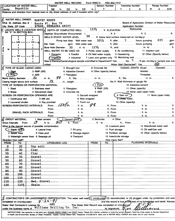
| Owner: Hoops, Harvey | Status: Constructed | ||
| Location: T1S, R4W, Sec. 7, NE SE SE | County: Republic | ||
| Directions: | |||
| Latitude: 39.975452 | Longitude: -97.8018367 | Datum NAD 27 | |
| Latitude: 39.9754629 | Longitude: -97.8021572 | Datum NAD 83 | |
| Longitude and latitude calculated by Survey from township-range-section-quarter calls. Only good to within the quarter call accuracy. | |||
| View well on interactive map | |||
| General Info | ||
| Well Depth: 123.5 ft. | Elevation: ft. | |
| Static Water Level: 98 ft. | Est. Yield: gpm. | |
| Comp. Date: 22-Apr-1991 | Well Use: Irrigation | |
| DWR Applic. #: | Other ID: | |
| Links | |
| View info from Wizard Water Level Data base... | |
| View info from WIMAS Water Right Data base... | |
| Driller Info | ||
| Driller: Ron Williams Drilling Co., Inc. | License #: 480 | |
| Scanned Form | View scan |
|
Chemical Sample Submitted?: No
Water Well disinfected?: | ||
| Ground water encountered: 0 ft. , 0 ft. , 0 ft. | ||
| Pump test data: Well water was 101 ft after 3 hours pumping 35 gpm | ||
| Casing Info | ||
| Casing Type: PVC
Casing Joints: |
Diam: 16 in. to 98 ft
Diam: 0 in. to 0 ft Diam: 0 in. to 0 ft | |
| Casing height above land surface: in
Casing Weight: lbs/ft Wall thickness or gauge no.: | ||
| Screen and Perforation Info | ||
| Screen Type: PVC | Screen Openings: Saw cut | |
| Screen-perforated intervals | From: 98 ft to 123 ft
From: 0 ft to 0 ft From: 0 ft to 0 ft | |
| Gravel pack intervals | From: ft to ft | |
| Grout Info | ||
| Grout used: Cement grout | From: 0 to 20 ft
From: 0 to 0 ft From: 0 to 0 ft | |
| Source of Possible Contamination | ||
| Source: Septic Tank | ||
| Direction from well: | Distance: 0 ft | |
| Lithologic Log
(Log data entered by KGS.) | ||
| From: 0 ft. to 20 ft. | top soil | |
| From: 20 ft. to 30 ft. | clay | |
| From: 30 ft. to 40 ft. | clay | |
| From: 40 ft. to 50 ft. | gravel | |
| From: 50 ft. to 60 ft. | gravel | |
| From: 60 ft. to 70 ft. | gravel | |
| From: 70 ft. to 80 ft. | gravel | |
| From: 80 ft. to 90 ft. | gravel | |
| From: 90 ft. to 100 ft. | gravel | |
| From: 100 ft. to 110 ft. | gravel | |
| From: 110 ft. to 120 ft. | medium gravel | |
| From: 120 ft. to 123.5 ft. | shale | |