|
|
|
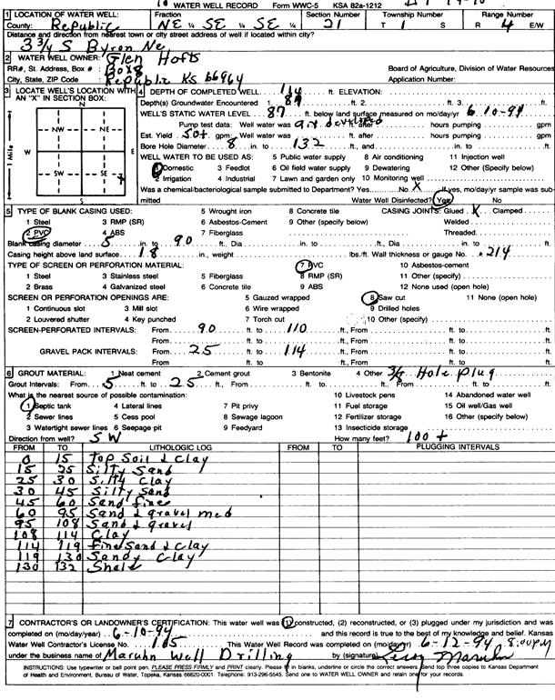
Specific Water Well Detail |
|
|
| Location Info | |||
| Owner: Hofts, Glen | Status: Constructed | ||
| Location: T1S, R4W, Sec. 21, NE SE SE | County: Republic | ||
| Directions: from Byron, NE, 3.75 mi S | |||
| Latitude: 39.9463775 | Longitude: -97.7640522 | Datum NAD 27 | |
| Latitude: 39.9463874 | Longitude: -97.7643727 | Datum NAD 83 | |
| Longitude and latitude calculated by Survey from township-range-section-quarter calls. Only good to within the quarter call accuracy. | |||
| View well on interactive map | |||
| General Info | ||
| Well Depth: 114 ft. | Elevation: ft. | |
| Static Water Level: 87 ft. | Est. Yield: 50 gpm. | |
| Comp. Date: 10-Jun-1994 | Well Use: Domestic | |
| DWR Applic. #: | Other ID: | |
| Driller Info | ||
| Driller: Leroy Maruhn Well Drilling, Inc. | License #: 165 | |
| Scanned Form | View scan |
|
Chemical Sample Submitted?: No
Water Well disinfected?: | ||
| Ground water encountered: 87 ft. , 0 ft. , 0 ft. | ||
| Pump test data: Well water was 0 ft after 0 hours pumping 0 gpm | ||
| Casing Info | ||
| Casing Type: PVC
Casing Joints: |
Diam: 5 in. to 90 ft
Diam: 0 in. to 0 ft Diam: 0 in. to 0 ft | |
| Casing height above land surface: in
Casing Weight: lbs/ft Wall thickness or gauge no.: | ||
| Screen and Perforation Info | ||
| Screen Type: PVC | Screen Openings: Saw cut | |
| Screen-perforated intervals | From: 90 ft to 110 ft
From: 0 ft to 0 ft From: 0 ft to 0 ft | |
| Gravel pack intervals | From: ft to ft | |
| Grout Info | ||
| Grout used: | From: 5 to 25 ft
From: 0 to 0 ft From: 0 to 0 ft | |
| Source of Possible Contamination | ||
| Source: Septic Tank | ||
| Direction from well: | Distance: 0 ft | |
| Lithologic Log
(Log data entered by KGS.) | ||
| From: 0 ft. to 15 ft. | top soil and clay | |
| From: 15 ft. to 25 ft. | silty sand | |
| From: 25 ft. to 30 ft. | silty clay | |
| From: 30 ft. to 45 ft. | silty sand | |
| From: 45 ft. to 60 ft. | sand, fine | |
| From: 60 ft. to 95 ft. | sand and gravel, medium | |
| From: 95 ft. to 108 ft. | sand and gravel | |
| From: 108 ft. to 114 ft. | clay | |
| From: 114 ft. to 119 ft. | fine sand and clay | |
| From: 119 ft. to 130 ft. | sandy clay | |
| From: 130 ft. to 132 ft. | shale | |