|
|
|
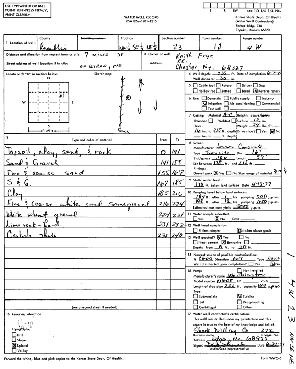
Specific Water Well Detail |
|
|
| Location Info | |||
| Owner: Frye, Keith | Status: Constructed | ||
| Location: T1S, R4W, Sec. 23, NW SE NE | County: Republic | ||
| Directions: from Byron, 7 mi SE | |||
| Latitude: 39.9536763 | Longitude: -97.7289489 | Datum NAD 27 | |
| Latitude: 39.9536857 | Longitude: -97.7292691 | Datum NAD 83 | |
| Longitude and latitude calculated by Survey from township-range-section-quarter calls. Only good to within the quarter call accuracy. | |||
| View well on interactive map | |||
| General Info | ||
| Well Depth: 235 ft. | Elevation: ft. | |
| Static Water Level: 170 ft. | Est. Yield: 2000 gpm. | |
| Comp. Date: 07-Jun-1977 | Well Use: Irrigation | |
| DWR Applic. #: | Other ID: | |
| Links | |
| No Wizard information available. | |
| View info from WIMAS Water Right Data base... | |
| Driller Info | ||
| Driller: Dale Shuck Drilling Co. | License #: 272 | |
| Scanned Form | View scan |
|
Chemical Sample Submitted?: No
Water Well disinfected?: | ||
| Ground water encountered: 0 ft. , 0 ft. , 0 ft. | ||
| Pump test data: Well water was 0 ft after 0 hours pumping 0 gpm | ||
| Casing Info | ||
| Casing Type:
Casing Joints: |
Diam: 0 in. to 0 ft
Diam: 0 in. to 0 ft Diam: 0 in. to 0 ft | |
| Casing height above land surface: in
Casing Weight: lbs/ft Wall thickness or gauge no.: | ||
| Screen and Perforation Info | ||
| Screen Type: | Screen Openings: | |
| Screen-perforated intervals | From: 178 ft to 235 ft
From: 0 ft to 0 ft From: 0 ft to 0 ft | |
| Gravel pack intervals | From: ft to ft | |
| Grout Info | ||
| Grout used: | From: 0 to 0 ft
From: 0 to 0 ft From: 0 to 0 ft | |
| Source of Possible Contamination | ||
| Source: | ||
| Direction from well: | Distance: 0 ft | |
| Lithologic Log
(Log data entered by KGS.) | ||
| From: 0 ft. to 141 ft. | top soil, clay, sand, and rock | |
| From: 141 ft. to 155 ft. | sand and gravel | |
| From: 155 ft. to 167 ft. | fine and coarse sand | |
| From: 167 ft. to 185 ft. | sand and gravel | |
| From: 185 ft. to 216 ft. | clay | |
| From: 216 ft. to 224 ft. | fine and coarse white sand, some gravel | |
| From: 224 ft. to 231 ft. | white wheat gravel | |
| From: 231 ft. to 232 ft. | lime rock, hard | |
| From: 232 ft. to 240 ft. | Carlisle shale | |