|
|
|
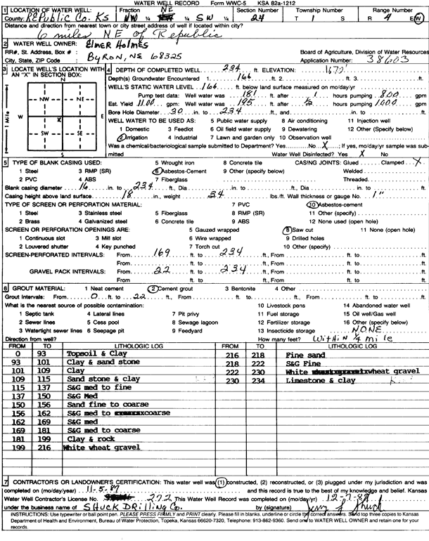
Specific Water Well Detail |
|
|
| Location Info | |||
| Owner: Holmes, Elmer | Status: Constructed | ||
| Location: T1S, R4W, Sec. 24, NW NE SW | County: Republic | ||
| Directions: from Republic, 6 mi NE | |||
| Latitude: 39.9500524 | Longitude: -97.7195494 | Datum NAD 27 | |
| Latitude: 39.9500616 | Longitude: -97.7198696 | Datum NAD 83 | |
| Longitude and latitude calculated by Survey from township-range-section-quarter calls. Only good to within the quarter call accuracy. | |||
| View well on interactive map | |||
| General Info | ||
| Well Depth: 234 ft. | Elevation: ft. | |
| Static Water Level: 166 ft. | Est. Yield: 1100 gpm. | |
| Comp. Date: 05-Nov-1987 | Well Use: Irrigation | |
| DWR Applic. #: 38603 | Other ID: | |
| Links | |
| View info from Wizard Water Level Data base... | |
| View info from WIMAS Water Right Data base... | |
| Driller Info | ||
| Driller: Dale Shuck Drilling Co. | License #: 272 | |
| Scanned Form | View scan |
|
Chemical Sample Submitted?: No
Water Well disinfected?: | ||
| Ground water encountered: 166 ft. , 0 ft. , 0 ft. | ||
| Pump test data: Well water was 181 ft after 1 hours pumping 800 gpm | ||
| Casing Info | ||
| Casing Type: ASBESTOS-CEMENT
Casing Joints: |
Diam: 16 in. to 234 ft
Diam: 0 in. to 0 ft Diam: 0 in. to 0 ft | |
| Casing height above land surface: in
Casing Weight: lbs/ft Wall thickness or gauge no.: | ||
| Screen and Perforation Info | ||
| Screen Type: ASBESTOS-CEMENT | Screen Openings: Saw cut | |
| Screen-perforated intervals | From: 169 ft to 234 ft
From: 0 ft to 0 ft From: 0 ft to 0 ft | |
| Gravel pack intervals | From: ft to ft | |
| Grout Info | ||
| Grout used: Cement grout | From: 0 to 22 ft
From: 0 to 0 ft From: 0 to 0 ft | |
| Source of Possible Contamination | ||
| Source: OTHER | ||
| Direction from well: | Distance: 0 ft | |
| Lithologic Log
(Log data entered by KGS.) | ||
| From: 0 ft. to 93 ft. | top soil and clay | |
| From: 93 ft. to 101 ft. | clay and sandstone | |
| From: 101 ft. to 109 ft. | clay | |
| From: 109 ft. to 115 ft. | sandstone and clay | |
| From: 115 ft. to 137 ft. | sand and gravel, medium to fine | |
| From: 137 ft. to 150 ft. | sand and gravel, medium | |
| From: 150 ft. to 156 ft. | sand, fine to coarse | |
| From: 156 ft. to 162 ft. | sand and gravel, medium to coarse | |
| From: 162 ft. to 169 ft. | sand and gravel, medium | |
| From: 169 ft. to 181 ft. | sand and gravel, medium to coarse | |
| From: 181 ft. to 199 ft. | clay and rock | |
| From: 199 ft. to 216 ft. | white wheat gravel | |
| From: 216 ft. to 218 ft. | fine sand | |
| From: 218 ft. to 222 ft. | sand and gravel, fine | |
| From: 222 ft. to 230 ft. | white wheat gravel | |
| From: 230 ft. to 234 ft. | limestone and clay | |