|
|
|
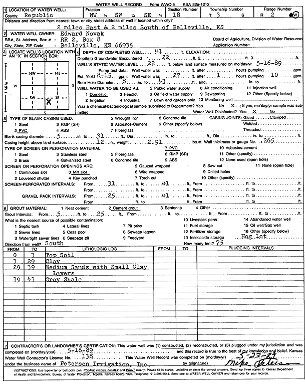
Specific Water Well Detail |
|
|
| Location Info | |||
| Owner: Novak, Edward | Status: Constructed | ||
| Location: T3S, R2W, Sec. 18, NW SW SE | County: Republic | ||
| Directions: from Belleville, 2 mi E and 2 mi S | |||
| Latitude: 39.7864256 | Longitude: -97.5842995 | Datum NAD 27 | |
| Latitude: 39.7864301 | Longitude: -97.5846181 | Datum NAD 83 | |
| Longitude and latitude calculated by Survey from township-range-section-quarter calls. Only good to within the quarter call accuracy. | |||
| View well on interactive map | |||
| General Info | ||
| Well Depth: 41 ft. | Elevation: ft. | |
| Static Water Level: 22 ft. | Est. Yield: 15 gpm. | |
| Comp. Date: 16-May-1989 | Well Use: Domestic | |
| DWR Applic. #: | Other ID: | |
| Driller Info | ||
| Driller: Michael Peterson Irrigation, Inc. | License #: 138 | |
| Scanned Form | View scan |
|
Chemical Sample Submitted?: No
Water Well disinfected?: | ||
| Ground water encountered: 22 ft. , 0 ft. , 0 ft. | ||
| Pump test data: Well water was 0 ft after 0 hours pumping 0 gpm | ||
| Casing Info | ||
| Casing Type: PVC
Casing Joints: |
Diam: 5 in. to 31 ft
Diam: 0 in. to 0 ft Diam: 0 in. to 0 ft | |
| Casing height above land surface: in
Casing Weight: lbs/ft Wall thickness or gauge no.: | ||
| Screen and Perforation Info | ||
| Screen Type: PVC | Screen Openings: Mill slot | |
| Screen-perforated intervals | From: 31 ft to 41 ft
From: 0 ft to 0 ft From: 0 ft to 0 ft | |
| Gravel pack intervals | From: ft to ft | |
| Grout Info | ||
| Grout used: Cement grout | From: 5 to 25 ft
From: 0 to 0 ft From: 0 to 0 ft | |
| Source of Possible Contamination | ||
| Source: OTHER | ||
| Direction from well: | Distance: 0 ft | |
| Lithologic Log
(Log data entered by KGS.) | ||
| From: 0 ft. to 3 ft. | top soil | |
| From: 3 ft. to 29 ft. | clay | |
| From: 29 ft. to 39 ft. | medium sand with small clay layers | |
| From: 39 ft. to 43 ft. | gray shale | |