|
|
|
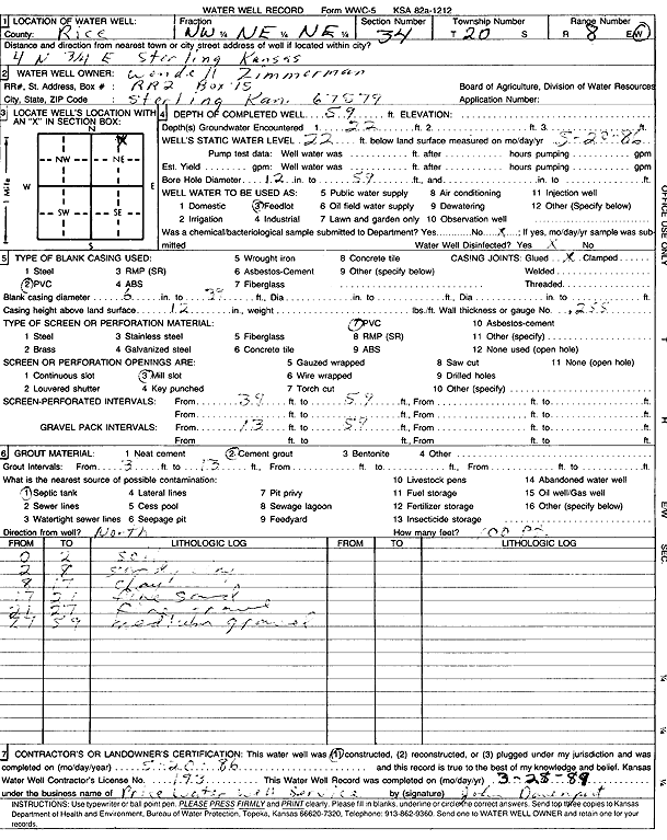
Specific Water Well Detail |
|
|
| Location Info | |||
| Owner: Zimmerman, Wendell | Status: Constructed | ||
| Location: T20S, R8W, Sec. 34, NW NE NE | County: Rice | ||
| Directions: from Sterling: 4 mi N, .75 mi E | |||
| Latitude: 38.2741227 | Longitude: -98.1866368 | Datum NAD 27 | |
| Latitude: 38.2741334 | Longitude: -98.1869748 | Datum NAD 83 | |
| Longitude and latitude calculated by Survey from township-range-section-quarter calls. Only good to within the quarter call accuracy. | |||
| View well on interactive map | |||
| General Info | ||
| Well Depth: 59 ft. | Elevation: ft. | |
| Static Water Level: 22 ft. | Est. Yield: gpm. | |
| Comp. Date: 20-May-1986 | Well Use: Feedlot | |
| DWR Applic. #: | Other ID: | |
| Links | |
| No Wizard information available. | |
| View info from WIMAS Water Right Data base... | |
| Driller Info | ||
| Driller: Price Water Well Service | License #: 193 | |
| Scanned Form | View scan |
|
Chemical Sample Submitted?: No
Water Well disinfected?: | ||
| Ground water encountered: 22 ft. , 0 ft. , 0 ft. | ||
| Pump test data: Well water was 0 ft after 0 hours pumping 0 gpm | ||
| Casing Info | ||
| Casing Type: PVC
Casing Joints: |
Diam: 6 in. to 39 ft
Diam: 0 in. to 0 ft Diam: 0 in. to 0 ft | |
| Casing height above land surface: in
Casing Weight: lbs/ft Wall thickness or gauge no.: | ||
| Screen and Perforation Info | ||
| Screen Type: PVC | Screen Openings: Mill slot | |
| Screen-perforated intervals | From: 39 ft to 59 ft
From: 0 ft to 0 ft From: 0 ft to 0 ft | |
| Gravel pack intervals | From: ft to ft | |
| Grout Info | ||
| Grout used: Cement grout | From: 3 to 13 ft
From: 0 to 0 ft From: 0 to 0 ft | |
| Source of Possible Contamination | ||
| Source: Septic Tank | ||
| Direction from well: | Distance: 0 ft | |
| Lithologic Log
(Log data entered by KGS.) | ||
| From: 0 ft. to 2 ft. | soil | |
| From: 2 ft. to 8 ft. | sandy clay | |
| From: 8 ft. to 17 ft. | clay | |
| From: 17 ft. to 21 ft. | fine sand | |
| From: 21 ft. to 27 ft. | fine gravel | |
| From: 27 ft. to 59 ft. | medium gravel | |