|
|
|
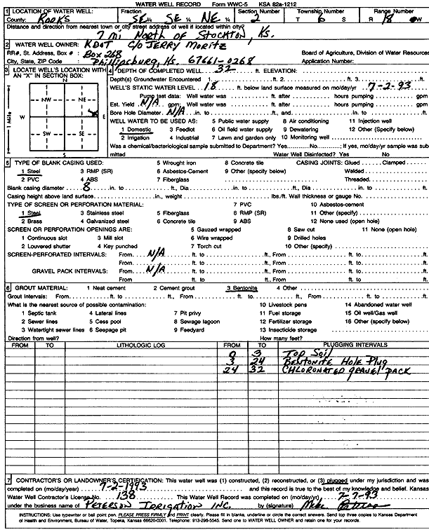
Specific Water Well Detail |
|
|
| Location Info | |||
| Owner: Kansas Dept. of Transportation, KDOT | Status: Plugged | ||
| Location: T6S, R18W, Sec. 2, SE SE NE | County: Rooks | ||
| Directions: from Stockton: 7 mi N | |||
| Latitude: 39.561033 | Longitude: -99.2865192 | Datum NAD 27 | |
| Latitude: 39.5610428 | Longitude: -99.2868934 | Datum NAD 83 | |
| Longitude and latitude calculated by Survey from township-range-section-quarter calls. Only good to within the quarter call accuracy. | |||
| View well on interactive map | |||
| General Info | ||
| Well Depth: 32 ft. | Elevation: ft. | |
| Static Water Level: 18 ft. | Est. Yield: gpm. | |
| Comp. Date: 02-Jul-1993 | Well Use: Domestic | |
| DWR Applic. #: | Other ID: | |
| Driller Info | ||
| Driller: Peterson Irrigation, Inc. | License #: 138 | |
| Scanned Form | View scan |
| Casing Info | ||
|
Casing Type: Steel
Diam: 8 in. Casing height above land surface: in | ||
| Grout Info | ||
| Grout used: Bentonite | From: 3 to 24 ft
From: 0 to 0 ft From: 0 to 0 ft | |
| Source of Possible Contamination | ||
| Source: OTHER | ||
| Direction from well: | Distance: 0 ft | |