|
|
|
Specific Water Well Detail |
|
|
| Location Info | |||
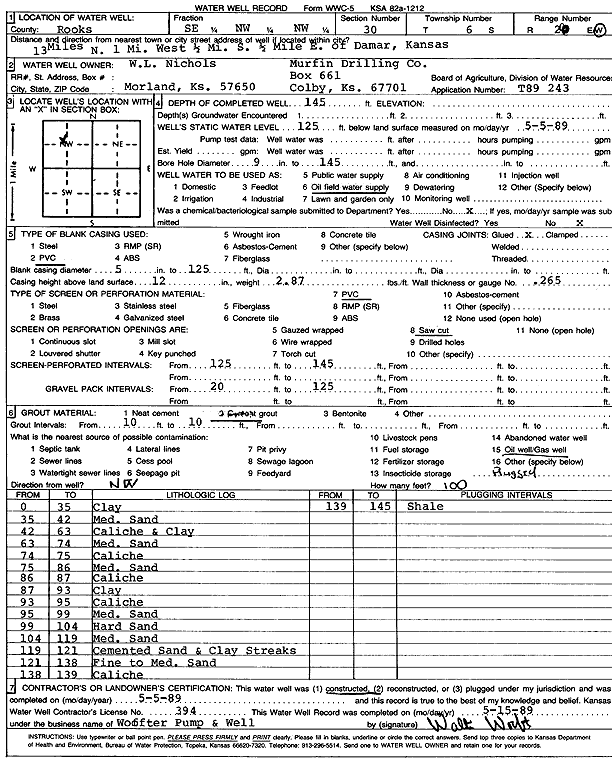
| Owner: Nichols, W. L./Murfin Drilling Co. | Status: Constructed | ||
| Location: T6S, R20W, Sec. 30, SE NW NW | County: Rooks | ||
| Directions: from Damar: 13 mi N, 1 mi W, .5 mi S, .5 mi E | |||
| Latitude: 39.5072291 | Longitude: -99.5982735 | Datum NAD 27 | |
| Latitude: 39.5072367 | Longitude: -99.5986606 | Datum NAD 83 | |
| Longitude and latitude calculated by Survey from township-range-section-quarter calls. Only good to within the quarter call accuracy. | |||
| View well on interactive map | |||
| General Info | ||
| Well Depth: 145 ft. | Elevation: ft. | |
| Static Water Level: 125 ft. | Est. Yield: gpm. | |
| Comp. Date: 05-May-1989 | Well Use: Oil Field Water Supply | |
| DWR Applic. #: T89-243 | Other ID: | |
| Driller Info | ||
| Driller: Walter Woofter Pump & Well | License #: 394 | |
| Scanned Form | View scan |
|
Chemical Sample Submitted?: No
Water Well disinfected?: | ||
| Ground water encountered: 0 ft. , 0 ft. , 0 ft. | ||
| Pump test data: Well water was 0 ft after 0 hours pumping 0 gpm | ||
| Casing Info | ||
| Casing Type: PVC
Casing Joints: |
Diam: 5 in. to 125 ft
Diam: 0 in. to 0 ft Diam: 0 in. to 0 ft | |
| Casing height above land surface: in
Casing Weight: lbs/ft Wall thickness or gauge no.: | ||
| Screen and Perforation Info | ||
| Screen Type: PVC | Screen Openings: Saw cut | |
| Screen-perforated intervals | From: 125 ft to 145 ft
From: 0 ft to 0 ft From: 0 ft to 0 ft | |
| Gravel pack intervals | From: ft to ft | |
| Grout Info | ||
| Grout used: Cement grout | From: 10 to 10 ft
From: 0 to 0 ft From: 0 to 0 ft | |
| Source of Possible Contamination | ||
| Source: Oil well/gas well | ||
| Direction from well: | Distance: 0 ft | |
| Lithologic Log
(Log data entered by KGS.) | ||
| From: 0 ft. to 35 ft. | clay | |
| From: 35 ft. to 42 ft. | medium sand | |
| From: 42 ft. to 63 ft. | caliche and clay | |
| From: 63 ft. to 74 ft. | medium sand | |
| From: 74 ft. to 75 ft. | caliche | |
| From: 75 ft. to 86 ft. | medium sand | |
| From: 86 ft. to 87 ft. | caliche | |
| From: 87 ft. to 93 ft. | clay | |
| From: 93 ft. to 95 ft. | caliche | |
| From: 95 ft. to 99 ft. | medium sand | |
| From: 99 ft. to 104 ft. | hard sand | |
| From: 104 ft. to 119 ft. | medium sand | |
| From: 119 ft. to 121 ft. | cemented sand and clay streaks | |
| From: 121 ft. to 138 ft. | fine to medium sand | |
| From: 138 ft. to 139 ft. | caliche | |
| From: 139 ft. to 145 ft. | shale | |