|
|
|
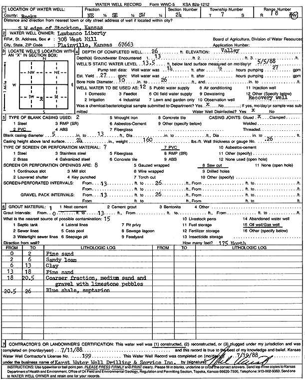
Specific Water Well Detail |
|
|
| Location Info | |||
| Owner: Lawbanco Liberty | Status: Constructed | ||
| Location: T7S, R18W, Sec. 24, NE SE SW | County: Rooks | ||
| Directions: SW edge of Stockton | |||
| Latitude: 39.4249752 | Longitude: -99.2782854 | Datum NAD 27 | |
| Latitude: 39.4249852 | Longitude: -99.2786606 | Datum NAD 83 | |
| Longitude and latitude calculated by Survey from township-range-section-quarter calls. Only good to within the quarter call accuracy. | |||
| View well on interactive map | |||
| General Info | ||
| Well Depth: 26 ft. | Elevation: ft. | |
| Static Water Level: 13.5 ft. | Est. Yield: 27 gpm. | |
| Comp. Date: 11-Jul-1988 | Well Use: Environmental Remediation, Recovery | |
| DWR Applic. #: | Other ID: | |
| Driller Info | ||
| Driller: Karst Water Well Drilling & Service, Inc. | License #: 199 | |
| Scanned Form | View scan |
|
Chemical Sample Submitted?: No
Water Well disinfected?: | ||
| Ground water encountered: 13 ft. , 0 ft. , 0 ft. | ||
| Pump test data: Well water was 14 ft after 1 hours pumping 27 gpm | ||
| Casing Info | ||
| Casing Type: PVC
Casing Joints: |
Diam: 5 in. to 13 ft
Diam: 0 in. to 0 ft Diam: 0 in. to 0 ft | |
| Casing height above land surface: in
Casing Weight: lbs/ft Wall thickness or gauge no.: | ||
| Screen and Perforation Info | ||
| Screen Type: PVC | Screen Openings: Saw cut | |
| Screen-perforated intervals | From: 13 ft to 26 ft
From: 0 ft to 0 ft From: 0 ft to 0 ft | |
| Gravel pack intervals | From: ft to ft | |
| Grout Info | ||
| Grout used: Neat cement | From: 0 to 13 ft
From: 0 to 0 ft From: 0 to 0 ft | |
| Source of Possible Contamination | ||
| Source: Oil well/gas well | ||
| Direction from well: | Distance: 0 ft | |
| Lithologic Log
(Log data entered by KGS.) | ||
| From: 0 ft. to 2 ft. | fine sand | |
| From: 2 ft. to 6 ft. | sandy loam | |
| From: 6 ft. to 13 ft. | clay | |
| From: 13 ft. to 18 ft. | fine sand | |
| From: 18 ft. to 20.5 ft. | coarser fraction, medium sand and gravel with limestone pebbles | |
| From: 20.5 ft. to 26 ft. | blue shale | |