|
|
|
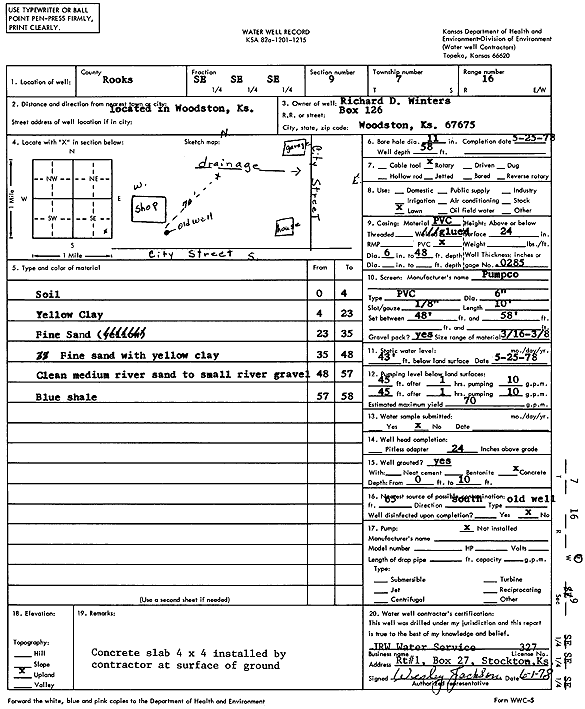
Specific Water Well Detail |
|
|
| Location Info | |||
| Owner: Winters, Richard D. | Status: Constructed | ||
| Location: T7S, R16W, Sec. 9, SE SE SE | County: Rooks | ||
| Directions: Woodston | |||
| Latitude: 39.4528007 | Longitude: -99.1019148 | Datum NAD 27 | |
| Latitude: 39.452811 | Longitude: -99.1022826 | Datum NAD 83 | |
| Longitude and latitude calculated by Survey from township-range-section-quarter calls. Only good to within the quarter call accuracy. | |||
| View well on interactive map | |||
| General Info | ||
| Well Depth: 58 ft. | Elevation: ft. | |
| Static Water Level: 43 ft. | Est. Yield: 70 gpm. | |
| Comp. Date: 25-May-1978 | Well Use: Domestic, Lawn and Garden | |
| DWR Applic. #: | Other ID: | |
| Driller Info | ||
| Driller: JRW Water Service | License #: 327 | |
| Scanned Form | View scan |
|
Chemical Sample Submitted?: No
Water Well disinfected?: | ||
| Ground water encountered: 0 ft. , 0 ft. , 0 ft. | ||
| Pump test data: Well water was 0 ft after 0 hours pumping 0 gpm | ||
| Casing Info | ||
| Casing Type:
Casing Joints: |
Diam: 0 in. to 0 ft
Diam: 0 in. to 0 ft Diam: 0 in. to 0 ft | |
| Casing height above land surface: in
Casing Weight: lbs/ft Wall thickness or gauge no.: | ||
| Screen and Perforation Info | ||
| Screen Type: | Screen Openings: | |
| Screen-perforated intervals | From: 48 ft to 58 ft
From: 0 ft to 0 ft From: 0 ft to 0 ft | |
| Gravel pack intervals | From: ft to ft | |
| Grout Info | ||
| Grout used: | From: 0 to 0 ft
From: 0 to 0 ft From: 0 to 0 ft | |
| Source of Possible Contamination | ||
| Source: | ||
| Direction from well: | Distance: 0 ft | |
| Lithologic Log
(Log data entered by KGS.) | ||
| From: 0 ft. to 4 ft. | soil | |
| From: 4 ft. to 23 ft. | yellow clay | |
| From: 23 ft. to 35 ft. | fine sand | |
| From: 35 ft. to 48 ft. | fine sand with yellow clay | |
| From: 48 ft. to 57 ft. | clean medium river sand to small river gravel | |
| From: 57 ft. to 58 ft. | blue shale | |