|
|
|
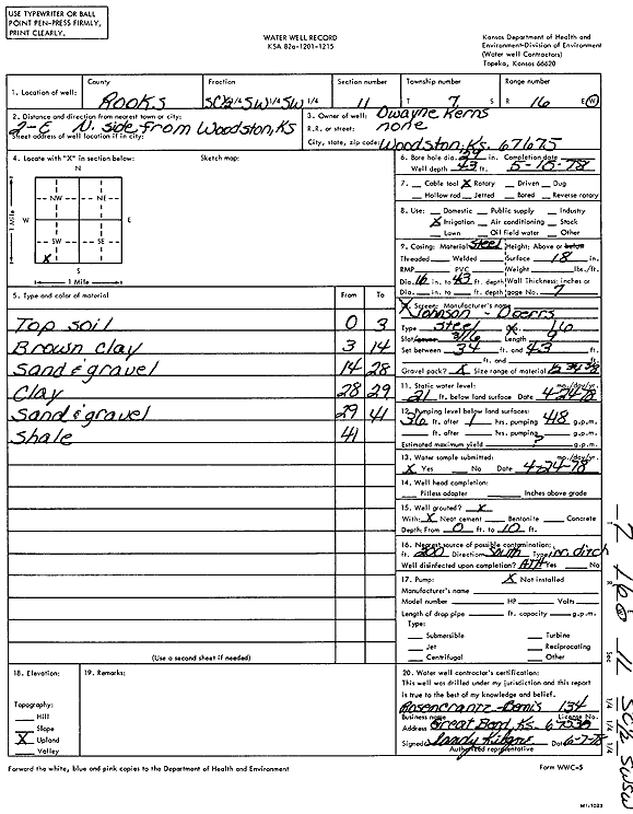
Specific Water Well Detail |
|
|
| Location Info | |||
| Owner: Kerns, Dwayne | Status: Constructed | ||
| Location: T7S, R16W, Sec. 11, S2 SW SW | County: Rooks | ||
| Directions: from Woodston: 2 mi E, N side | |||
| Latitude: 39.452713 | Longitude: -99.079397 | Datum NAD 27 | |
| Latitude: 39.4527234 | Longitude: -99.0797638 | Datum NAD 83 | |
| Longitude and latitude calculated by Survey from township-range-section-quarter calls. Only good to within the quarter call accuracy. | |||
| View well on interactive map | |||
| General Info | ||
| Well Depth: 43 ft. | Elevation: ft. | |
| Static Water Level: 21 ft. | Est. Yield: gpm. | |
| Comp. Date: 15-May-1978 | Well Use: Irrigation | |
| DWR Applic. #: | Other ID: | |
| Links | |
| No Wizard information available. | |
| View info from WIMAS Water Right Data base... | |
| Driller Info | ||
| Driller: Rosencrantz-Bemis Enterprises, Inc. | License #: 134 | |
| Scanned Form | View scan |
|
Chemical Sample Submitted?: Yes
Water Well disinfected?: | ||
| Ground water encountered: 0 ft. , 0 ft. , 0 ft. | ||
| Pump test data: Well water was 0 ft after 0 hours pumping 0 gpm | ||
| Casing Info | ||
| Casing Type:
Casing Joints: |
Diam: 0 in. to 0 ft
Diam: 0 in. to 0 ft Diam: 0 in. to 0 ft | |
| Casing height above land surface: in
Casing Weight: lbs/ft Wall thickness or gauge no.: | ||
| Screen and Perforation Info | ||
| Screen Type: | Screen Openings: | |
| Screen-perforated intervals | From: 34 ft to 43 ft
From: 0 ft to 0 ft From: 0 ft to 0 ft | |
| Gravel pack intervals | From: ft to ft | |
| Grout Info | ||
| Grout used: | From: 0 to 0 ft
From: 0 to 0 ft From: 0 to 0 ft | |
| Source of Possible Contamination | ||
| Source: | ||
| Direction from well: | Distance: 0 ft | |
| Lithologic Log
(Log data entered by KGS.) | ||
| From: 0 ft. to 3 ft. | topsoil | |
| From: 3 ft. to 14 ft. | brown clay | |
| From: 14 ft. to 28 ft. | sand and gravel | |
| From: 28 ft. to 29 ft. | clay | |
| From: 29 ft. to 41 ft. | sand and gravel | |
| From: 41 ft. to ft. | shale | |