|
|
|
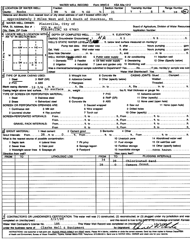
Specific Water Well Detail |
|
|
| Location Info | |||
| Owner: City of Plainville | Status: Plugged | ||
| Location: T7S, R18W, Sec. 21, NW SW SE | County: Rooks | ||
| Directions: from Stockton: 2 mi W, .75 mi S | |||
| Latitude: 39.4255711 | Longitude: -99.3317569 | Datum NAD 27 | |
| Latitude: 39.4255808 | Longitude: -99.3321342 | Datum NAD 83 | |
| Longitude and latitude calculated by Survey from township-range-section-quarter calls. Only good to within the quarter call accuracy. | |||
| View well on interactive map | |||
| General Info | ||
| Well Depth: 34 ft. | Elevation: ft. | |
| Static Water Level: 28 ft. | Est. Yield: gpm. | |
| Comp. Date: 17-Mar-1989 | Well Use: Public Water Supply | |
| DWR Applic. #: | Other ID: | |
| Links | |
| No Wizard information available. | |
| View info from WIMAS Water Right Data base... | |
| Driller Info | ||
| Driller: Clarke Well and Equipment, Inc. | License #: 185 | |
| Scanned Form | View scan |
| Casing Info | ||
|
Casing Type: Steel
Diam: 12 in. Casing height above land surface: in | ||
| Grout Info | ||
| Grout used: Cement grout | From: 0 to 28 ft
From: 0 to 0 ft From: 0 to 0 ft | |
| Source of Possible Contamination | ||
| Source: OTHER | ||
| Direction from well: | Distance: 0 ft | |