|
|
|
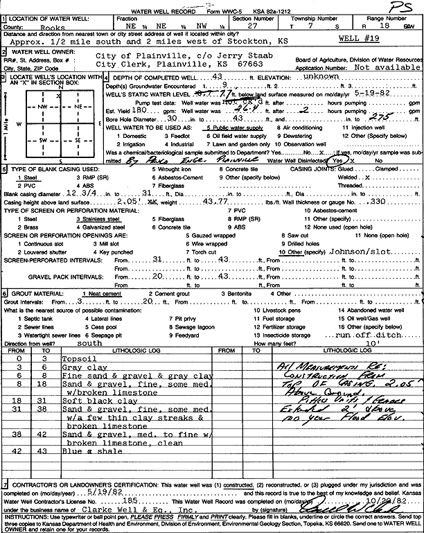
Specific Water Well Detail |
|
|
| Location Info | |||
| Owner: City of Plainville | Status: Constructed | ||
| Location: T7S, R18W, Sec. 27, NE NE NW | County: Rooks | ||
| Directions: from Stockton: .5 mi S, 2 mi W | |||
| Latitude: 39.4217588 | Longitude: -99.3155603 | Datum NAD 27 | |
| Latitude: 39.4217686 | Longitude: -99.315937 | Datum NAD 83 | |
| Longitude and latitude calculated by Survey from township-range-section-quarter calls. Only good to within the quarter call accuracy. | |||
| View well on interactive map | |||
| General Info | ||
| Well Depth: 43 ft. | Elevation: ft. | |
| Static Water Level: 7.7 ft. | Est. Yield: 180 gpm. | |
| Comp. Date: 19-May-1982 | Well Use: Public Water Supply | |
| DWR Applic. #: | Other ID: well 19 | |
| Links | |
| No Wizard information available. | |
| View info from WIMAS Water Right Data base... | |
| Driller Info | ||
| Driller: Clarke Well and Equipment, Inc. | License #: 185 | |
| Scanned Form | View scan |
|
Chemical Sample Submitted?: No
Water Well disinfected?: | ||
| Ground water encountered: 0 ft. , 0 ft. , 0 ft. | ||
| Pump test data: Well water was 0 ft after 0 hours pumping 0 gpm | ||
| Casing Info | ||
| Casing Type:
Casing Joints: |
Diam: 0 in. to 0 ft
Diam: 0 in. to 0 ft Diam: 0 in. to 0 ft | |
| Casing height above land surface: in
Casing Weight: lbs/ft Wall thickness or gauge no.: | ||
| Screen and Perforation Info | ||
| Screen Type: | Screen Openings: | |
| Screen-perforated intervals | From: 31 ft to 43 ft
From: 0 ft to 0 ft From: 0 ft to 0 ft | |
| Gravel pack intervals | From: ft to ft | |
| Grout Info | ||
| Grout used: | From: 0 to 0 ft
From: 0 to 0 ft From: 0 to 0 ft | |
| Source of Possible Contamination | ||
| Source: | ||
| Direction from well: | Distance: 0 ft | |
| Lithologic Log
(Log data entered by KGS.) | ||
| From: 0 ft. to 3 ft. | topsoil | |
| From: 3 ft. to 6 ft. | gray clay | |
| From: 6 ft. to 8 ft. | fine sand and gravel and gray clay | |
| From: 8 ft. to 18 ft. | sand and gravel, fine, some medium with broken limestone | |
| From: 18 ft. to 31 ft. | soft black clay | |
| From: 31 ft. to 38 ft. | sand and gravel, fine, some medium with a few thin clay streaks and broken limestone | |
| From: 38 ft. to 42 ft. | sand and gravel, medium to fine with broken limestone, clean | |
| From: 42 ft. to 43 ft. | blue and shale | |