|
|
|
Specific Water Well Detail |
|
|
| Location Info | |||
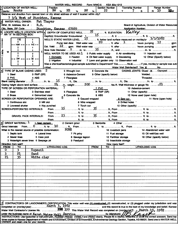
| Owner: Thayer, Pat | Status: Constructed | ||
| Location: T7S, R19W, Sec. 22, NW NE NW | County: Rooks | ||
| Directions: from Stockton: 7.75 mi W | |||
| Latitude: 39.4365481 | Longitude: -99.4291427 | Datum NAD 27 | |
| Latitude: 39.4365571 | Longitude: -99.4295236 | Datum NAD 83 | |
| Longitude and latitude calculated by Survey from township-range-section-quarter calls. Only good to within the quarter call accuracy. | |||
| View well on interactive map | |||
| General Info | ||
| Well Depth: 35 ft. | Elevation: ft. | |
| Static Water Level: 15 ft. | Est. Yield: 12 gpm. | |
| Comp. Date: 03-Mar-1982 | Well Use: Domestic | |
| DWR Applic. #: | Other ID: | |
| Driller Info | ||
| Driller: Melvin B. Karst Water Well Drilling & Service, Inc. | License #: 199 | |
| Scanned Form | View scan |
|
Chemical Sample Submitted?: No
Water Well disinfected?: | ||
| Ground water encountered: 0 ft. , 0 ft. , 0 ft. | ||
| Pump test data: Well water was 0 ft after 0 hours pumping 0 gpm | ||
| Casing Info | ||
| Casing Type:
Casing Joints: |
Diam: 0 in. to 0 ft
Diam: 0 in. to 0 ft Diam: 0 in. to 0 ft | |
| Casing height above land surface: in
Casing Weight: lbs/ft Wall thickness or gauge no.: | ||
| Screen and Perforation Info | ||
| Screen Type: | Screen Openings: | |
| Screen-perforated intervals | From: 15 ft to 35 ft
From: 0 ft to 0 ft From: 0 ft to 0 ft | |
| Gravel pack intervals | From: ft to ft | |
| Grout Info | ||
| Grout used: | From: 0 to 0 ft
From: 0 to 0 ft From: 0 to 0 ft | |
| Source of Possible Contamination | ||
| Source: | ||
| Direction from well: | Distance: 0 ft | |
| Lithologic Log
(Log data entered by KGS.) | ||
| From: 0 ft. to 3 ft. | topsoil | |
| From: 3 ft. to 21 ft. | sand | |
| From: 21 ft. to 35 ft. | white clay | |