|
|
|
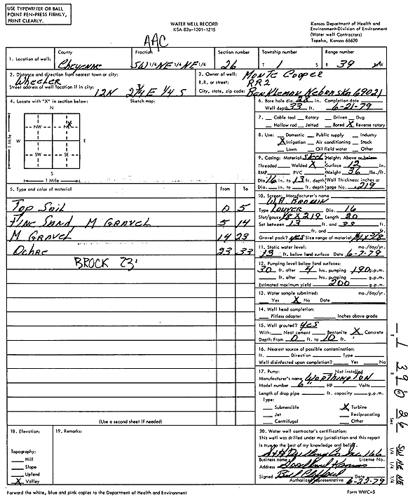
Specific Water Well Detail |
|
|
| Location Info | |||
| Owner: Cooper, Monte | Status: Constructed | ||
| Location: T1S, R39W, Sec. 26, SW NE NE | County: Cheyenne | ||
| Directions: from Wheeler, 12 mi N, 2.75 mi E and 0.25 mi S | |||
| Latitude: 39.9422238 | Longitude: -101.6577697 | Datum NAD 27 | |
| Latitude: 39.9422176 | Longitude: -101.6582177 | Datum NAD 83 | |
| Longitude and latitude calculated by Survey from township-range-section-quarter calls. Only good to within the quarter call accuracy. | |||
| View well on interactive map | |||
| General Info | ||
| Well Depth: 33 ft. | Elevation: ft. | |
| Static Water Level: 13 ft. | Est. Yield: 200 gpm. | |
| Comp. Date: 21-Jun-1979 | Well Use: Irrigation | |
| DWR Applic. #: | Other ID: | |
| Links | |
| No Wizard information available. | |
| View info from WIMAS Water Right Data base... | |
| Driller Info | ||
| Driller: S & H Drilling Co., Inc. | License #: 166 | |
| Scanned Form | View scan |
|
Chemical Sample Submitted?: No
Water Well disinfected?: | ||
| Ground water encountered: 0 ft. , 0 ft. , 0 ft. | ||
| Pump test data: Well water was 0 ft after 0 hours pumping 0 gpm | ||
| Casing Info | ||
| Casing Type:
Casing Joints: |
Diam: 0 in. to 0 ft
Diam: 0 in. to 0 ft Diam: 0 in. to 0 ft | |
| Casing height above land surface: in
Casing Weight: lbs/ft Wall thickness or gauge no.: | ||
| Screen and Perforation Info | ||
| Screen Type: | Screen Openings: | |
| Screen-perforated intervals | From: 13 ft to 33 ft
From: 0 ft to 0 ft From: 0 ft to 0 ft | |
| Gravel pack intervals | From: ft to ft | |
| Grout Info | ||
| Grout used: | From: 0 to 0 ft
From: 0 to 0 ft From: 0 to 0 ft | |
| Source of Possible Contamination | ||
| Source: | ||
| Direction from well: | Distance: 0 ft | |
| Lithologic Log
(Log data entered by KGS.) | ||
| From: 0 ft. to 5 ft. | Topsoil | |
| From: 5 ft. to 14 ft. | Fine sand, medium gravel | |
| From: 14 ft. to 23 ft. | Medium gravel | |
| From: 23 ft. to 33 ft. | Ochre | |