|
|
|
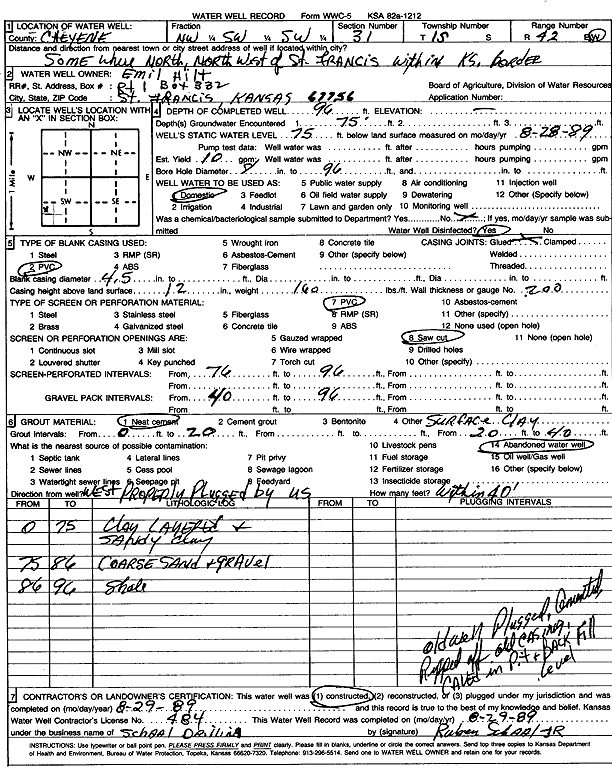
Specific Water Well Detail |
|
|
| Location Info | |||
| Owner: Hilt, Emil | Status: Constructed | ||
| Location: T1S, R42W, Sec. 31, NW SW SW | County: Cheyenne | ||
| Directions: North-northwest of St. Francis, within Kansas border | |||
| Latitude: | Longitude: | Datum NAD 27 | |
| Latitude: | Longitude: | Datum NAD 83 | |
| Longitude and latitude calculated by Survey from township-range-section-quarter calls. Only good to within the quarter call accuracy. | |||
| View well on interactive map | |||
| General Info | ||
| Well Depth: 96 ft. | Elevation: ft. | |
| Static Water Level: 75 ft. | Est. Yield: 10 gpm. | |
| Comp. Date: 29-Aug-1989 | Well Use: Domestic | |
| DWR Applic. #: | Other ID: | |
| Driller Info | ||
| Driller: Ruben T. Schaal Drilling Co. | License #: 484 | |
| Scanned Form | View scan |
|
Chemical Sample Submitted?: No
Water Well disinfected?: | ||
| Ground water encountered: 75 ft. , 0 ft. , 0 ft. | ||
| Pump test data: Well water was 0 ft after 0 hours pumping 0 gpm | ||
| Casing Info | ||
| Casing Type: PVC
Casing Joints: |
Diam: 4 in. to 0 ft
Diam: 0 in. to 0 ft Diam: 0 in. to 0 ft | |
| Casing height above land surface: in
Casing Weight: lbs/ft Wall thickness or gauge no.: | ||
| Screen and Perforation Info | ||
| Screen Type: PVC | Screen Openings: Saw cut | |
| Screen-perforated intervals | From: 76 ft to 96 ft
From: 0 ft to 0 ft From: 0 ft to 0 ft | |
| Gravel pack intervals | From: ft to ft | |
| Grout Info | ||
| Grout used: Neat cement, | From: 0 to 20 ft
From: 0 to 0 ft From: 0 to 0 ft | |
| Source of Possible Contamination | ||
| Source: Abandoned water well | ||
| Direction from well: | Distance: 0 ft | |
| Lithologic Log
(Log data entered by KGS.) | ||
| From: 0 ft. to 75 ft. | Clay layers and sandy clay | |
| From: 75 ft. to 86 ft. | Coarse sand and gravel | |
| From: 86 ft. to 96 ft. | Shale | |