|
|
|
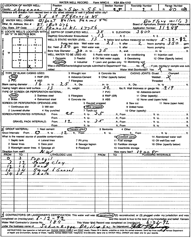
Specific Water Well Detail |
|
|
| Location Info | |||
| Owner: Albert Keller Farms | Status: Constructed | ||
| Location: T2S, R40W, Sec. 25, SW SW SE | County: Cheyenne | ||
| Directions: From St. Francis, 5 miles North and 3 miles East (battery of 3 wells) | |||
| Latitude: 39.8442756 | Longitude: -101.7562119 | Datum NAD 27 | |
| Latitude: 39.8442684 | Longitude: -101.7566629 | Datum NAD 83 | |
| Longitude and latitude calculated by Survey from township-range-section-quarter calls. Only good to within the quarter call accuracy. | |||
| View well on interactive map | |||
| General Info | ||
| Well Depth: 35 ft. | Elevation: 3400 ft. | |
| Static Water Level: 13 ft. | Est. Yield: 350 gpm. | |
| Comp. Date: 12-Jun-1992 | Well Use: Irrigation | |
| DWR Applic. #: 11248 | Other ID: | |
| Links | |
| No Wizard information available. | |
| View info from WIMAS Water Right Data base... | |
| Driller Info | ||
| Driller: Schoenrogge Drilling, Inc. | License #: 184 | |
| Scanned Form | View scan |
|
Chemical Sample Submitted?: No
Water Well disinfected?: | ||
| Ground water encountered: 13 ft. , 0 ft. , 0 ft. | ||
| Pump test data: Well water was 23 ft after 2 hours pumping 350 gpm | ||
| Casing Info | ||
| Casing Type: Steel
Casing Joints: |
Diam: 16 in. to 25 ft
Diam: 0 in. to 0 ft Diam: 0 in. to 0 ft | |
| Casing height above land surface: in
Casing Weight: lbs/ft Wall thickness or gauge no.: | ||
| Screen and Perforation Info | ||
| Screen Type: Steel | Screen Openings: Wire wrapped | |
| Screen-perforated intervals | From: 25 ft to 35 ft
From: 0 ft to 0 ft From: 0 ft to 0 ft | |
| Gravel pack intervals | From: ft to ft | |
| Grout Info | ||
| Grout used: Cement grout | From: 0 to 12 ft
From: 0 to 0 ft From: 0 to 0 ft | |
| Source of Possible Contamination | ||
| Source: Livestock pens | ||
| Direction from well: | Distance: 0 ft | |
| Lithologic Log
(Log data entered by KGS.) | ||
| From: 0 ft. to 3 ft. | Topsoil | |
| From: 3 ft. to 12 ft. | Sandy clay | |
| From: 12 ft. to 16 ft. | Sand | |
| From: 16 ft. to 34 ft. | Sand and gravel | |
| From: 34 ft. to 35 ft. | Shale | |