|
|
|
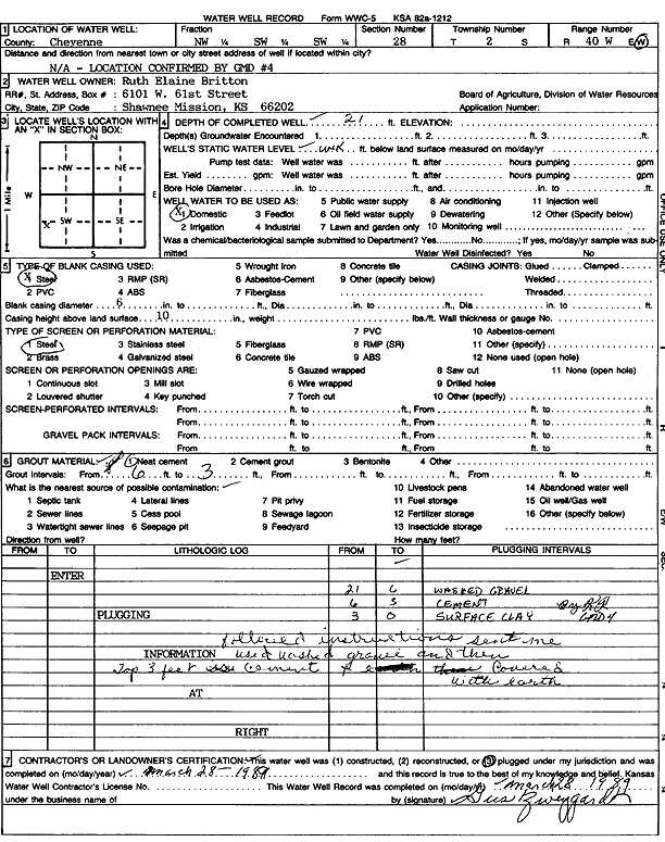
Specific Water Well Detail |
|
|
| Location Info | |||
| Owner: Britton, Ruth Elaine | Status: Plugged | ||
| Location: T2S, R40W, Sec. 28, NW SW SW | County: Cheyenne | ||
| Directions: N/A LOCATION CONFIRMED BY GMD #4 | |||
| Latitude: 39.8462978 | Longitude: -101.8219455 | Datum NAD 27 | |
| Latitude: 39.8462905 | Longitude: -101.8223993 | Datum NAD 83 | |
| Longitude and latitude calculated by Survey from township-range-section-quarter calls. Only good to within the quarter call accuracy. | |||
| View well on interactive map | |||
| General Info | ||
| Well Depth: 21 ft. | Elevation: ft. | |
| Static Water Level: ft. | Est. Yield: gpm. | |
| Comp. Date: 28-Mar-1989 | Well Use: Domestic | |
| DWR Applic. #: | Other ID: | |
| Driller Info | ||
| Driller: unknown | License #: | |
| Scanned Form | View scan |
| Casing Info | ||
|
Casing Type: Steel
Diam: 6 in. Casing height above land surface: in | ||
| Grout Info | ||
| Grout used: Neat cement | From: 3 to 6 ft
From: 0 to 0 ft From: 0 to 0 ft | |
| Source of Possible Contamination | ||
| Source: | ||
| Direction from well: | Distance: 0 ft | |