|
|
|
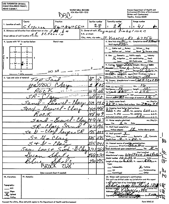
Specific Water Well Detail |
|
|
| Location Info | |||
| Owner: Zimbelman, Raymond | Status: Constructed | ||
| Location: T2S, R41W, Sec. 28, SW NW SE | County: Cheyenne | ||
| Directions: from St. Francis, 5 mi N and 6 mi W | |||
| Latitude: 39.8480247 | Longitude: -101.9256816 | Datum NAD 27 | |
| Latitude: 39.848017 | Longitude: -101.9261398 | Datum NAD 83 | |
| Longitude and latitude calculated by Survey from township-range-section-quarter calls. Only good to within the quarter call accuracy. | |||
| View well on interactive map | |||
| General Info | ||
| Well Depth: 275 ft. | Elevation: ft. | |
| Static Water Level: 227 ft. | Est. Yield: 650 gpm. | |
| Comp. Date: 24-May-1976 | Well Use: Irrigation | |
| DWR Applic. #: | Other ID: | |
| Links | |
| View info from Wizard Water Level Data base... | |
| View info from WIMAS Water Right Data base... | |
| Driller Info | ||
| Driller: Schoenrogge Drilling, Inc. | License #: 184 | |
| Scanned Form | View scan |
|
Chemical Sample Submitted?: No
Water Well disinfected?: | ||
| Ground water encountered: 0 ft. , 0 ft. , 0 ft. | ||
| Pump test data: Well water was 0 ft after 0 hours pumping 0 gpm | ||
| Casing Info | ||
| Casing Type:
Casing Joints: |
Diam: 0 in. to 0 ft
Diam: 0 in. to 0 ft Diam: 0 in. to 0 ft | |
| Casing height above land surface: in
Casing Weight: lbs/ft Wall thickness or gauge no.: | ||
| Screen and Perforation Info | ||
| Screen Type: | Screen Openings: | |
| Screen-perforated intervals | From: 265 ft to 275 ft
From: 0 ft to 0 ft From: 0 ft to 0 ft | |
| Gravel pack intervals | From: ft to ft | |
| Grout Info | ||
| Grout used: | From: 0 to 0 ft
From: 0 to 0 ft From: 0 to 0 ft | |
| Source of Possible Contamination | ||
| Source: | ||
| Direction from well: | Distance: 0 ft | |
| Lithologic Log
(Log data entered by KGS.) | ||
| From: 0 ft. to 2 ft. | Topsoil | |
| From: 2 ft. to 105 ft. | Yellow clay | |
| From: 105 ft. to 107 ft. | Rock | |
| From: 107 ft. to 110 ft. | SR, clay | |
| From: 110 ft. to 140 ft. | Sand, gravel, clay | |
| From: 140 ft. to 148 ft. | Sand, gravel, clay | |
| From: 148 ft. to 149 ft. | Rock | |
| From: 149 ft. to 163 ft. | Sand, gravel, clay | |
| From: 163 ft. to 175 ft. | SR, clay, sand | |
| From: 175 ft. to 225 ft. | Sand and gravel, clay layers SR | |
| From: 225 ft. to 235 ft. | Sand and gravel, clay | |
| From: 235 ft. to 241 ft. | Sand and gravel, clay | |
| From: 241 ft. to 268 ft. | Semi loose sand and gravel, clay | |
| From: 268 ft. to 270 ft. | Green shale | |
| From: 270 ft. to 275 ft. | Blue shale | |