|
|
|
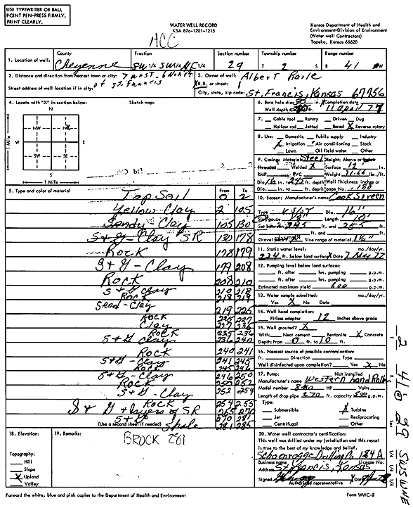
Specific Water Well Detail |
|
|
| Location Info | |||
| Owner: Raile, Albert | Status: Constructed | ||
| Location: T2S, R41W, Sec. 29, SW SW NE | County: Cheyenne | ||
| Directions: from St. Francis, 7 mi W and 6 mi N | |||
| Latitude: 39.8516166 | Longitude: -101.9445072 | Datum NAD 27 | |
| Latitude: 39.8516088 | Longitude: -101.9449663 | Datum NAD 83 | |
| Longitude and latitude calculated by Survey from township-range-section-quarter calls. Only good to within the quarter call accuracy. | |||
| View well on interactive map | |||
| General Info | ||
| Well Depth: 285 ft. | Elevation: ft. | |
| Static Water Level: 234 ft. | Est. Yield: 600 gpm. | |
| Comp. Date: 11-Apr-1977 | Well Use: Irrigation | |
| DWR Applic. #: | Other ID: | |
| Links | |
| View info from Wizard Water Level Data base... | |
| View info from WIMAS Water Right Data base... | |
| Driller Info | ||
| Driller: Schoenrogge Drilling, Inc. | License #: 184 | |
| Scanned Form | View scan |
|
Chemical Sample Submitted?: No
Water Well disinfected?: No | ||
| Ground water encountered: 0 ft. , 0 ft. , 0 ft. | ||
| Pump test data: Well water was 0 ft after 0 hours pumping 0 gpm | ||
| Bore hole diameter: 30 inches to 280 ft | ||
| Casing Info | ||
| Casing Type: Steel
Casing Joints: Welded |
Diam: 16 in. to 245 ft
Diam: 0 in. to 0 ft Diam: 0 in. to 0 ft | |
| Casing height above land surface: 12 in
Casing Weight: 31.66 lbs/ft Wall thickness or gauge no.: .188 | ||
| Screen and Perforation Info | ||
| Screen Type: | Screen Openings: Continuous slot | |
| Screen-perforated intervals | From: 245 ft to 255 ft
From: 0 ft to 0 ft From: 0 ft to 0 ft | |
| Gravel pack intervals | From: ft to ft | |
| Grout Info | ||
| Grout used: | From: 0 to 10 ft
From: 0 to 0 ft From: 0 to 0 ft | |
| Source of Possible Contamination | ||
| Source: | ||
| Direction from well: | Distance: 0 ft | |
| Lithologic Log
(Log data entered by KGS.) | ||
| From: 0 ft. to 2 ft. | Topsoil | |
| From: 2 ft. to 105 ft. | Yellow clay | |
| From: 105 ft. to 130 ft. | Sandy clay | |
| From: 130 ft. to 178 ft. | Sand and gravel, clay, sand rock | |
| From: 178 ft. to 179 ft. | Rock | |
| From: 179 ft. to 208 ft. | Sand and gravel, clay | |
| From: 208 ft. to 210 ft. | Rock | |
| From: 210 ft. to 218 ft. | Sand and gravel, clay | |
| From: 218 ft. to 219 ft. | Rock | |
| From: 219 ft. to 225 ft. | Sand, clay | |
| From: 225 ft. to 227 ft. | Rock | |
| From: 227 ft. to 235 ft. | Clay | |
| From: 235 ft. to 236 ft. | Rock | |
| From: 236 ft. to 240 ft. | Sand and gravel, clay | |
| From: 240 ft. to 241 ft. | Rock | |
| From: 241 ft. to 245 ft. | Sand and gravel, clay | |
| From: 245 ft. to 246 ft. | Rock | |
| From: 246 ft. to 250 ft. | Sand and gravel, clay | |
| From: 250 ft. to 252 ft. | Rock | |
| From: 252 ft. to 254 ft. | Sand and gravel, clay | |
| From: 254 ft. to 255 ft. | Rock | |
| From: 255 ft. to 270 ft. | Sand and gravel, layers of sand rock | |
| From: 270 ft. to 281 ft. | Sand and gravel | |
| From: 281 ft. to 285 ft. | Shale | |