|
|
|
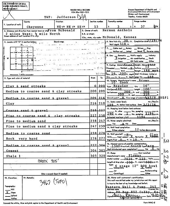
Specific Water Well Detail |
|
|
| Location Info | |||
| Owner: Antholz, Herman | Status: Constructed | ||
| Location: T3S, R37W, Sec. 13, NE NE SE | County: Cheyenne | ||
| Directions: from McDonald, 2 mi W and 0.5 mi N | |||
| Latitude: 39.7921583 | Longitude: -101.4108228 | Datum NAD 27 | |
| Latitude: 39.7921548 | Longitude: -101.4112638 | Datum NAD 83 | |
| Longitude and latitude calculated by Survey from township-range-section-quarter calls. Only good to within the quarter call accuracy. | |||
| View well on interactive map | |||
| General Info | ||
| Well Depth: 310 ft. | Elevation: ft. | |
| Static Water Level: 199 ft. | Est. Yield: 1194 gpm. | |
| Comp. Date: 29-Feb-1976 | Well Use: Irrigation | |
| DWR Applic. #: | Other ID: | |
| Links | |
| View info from Wizard Water Level Data base... | |
| View info from WIMAS Water Right Data base... | |
| Driller Info | ||
| Driller: Western Well & Pump, Inc. | License #: 245 | |
| Scanned Form | View scan |
|
Chemical Sample Submitted?: No
Water Well disinfected?: | ||
| Ground water encountered: 0 ft. , 0 ft. , 0 ft. | ||
| Pump test data: Well water was 0 ft after 0 hours pumping 0 gpm | ||
| Casing Info | ||
| Casing Type:
Casing Joints: |
Diam: 0 in. to 0 ft
Diam: 0 in. to 0 ft Diam: 0 in. to 0 ft | |
| Casing height above land surface: in
Casing Weight: lbs/ft Wall thickness or gauge no.: | ||
| Screen and Perforation Info | ||
| Screen Type: | Screen Openings: | |
| Screen-perforated intervals | From: 200 ft to 300 ft
From: 300 ft to 310 ft From: 0 ft to 0 ft | |
| Gravel pack intervals | From: ft to ft | |
| Grout Info | ||
| Grout used: | From: 0 to 0 ft
From: 0 to 0 ft From: 0 to 0 ft | |
| Source of Possible Contamination | ||
| Source: | ||
| Direction from well: | Distance: 0 ft | |
| Lithologic Log
(Log data entered by KGS.) | ||
| From: 0 ft. to 200 ft. | Clay and sand streaks | |
| From: 200 ft. to 209 ft. | Medium to coarse sand and clay streaks | |
| From: 209 ft. to 216 ft. | Medium to coarse sand and gravel | |
| From: 216 ft. to 218 ft. | Clay | |
| From: 218 ft. to 227 ft. | Coarse sand and gravel | |
| From: 227 ft. to 238 ft. | Fine to coarse sand and clay streaks | |
| From: 238 ft. to 247 ft. | Fine to medium sand | |
| From: 247 ft. to 259 ft. | Fine to medium sand and clay streaks | |
| From: 259 ft. to 276 ft. | Medium to coarse sand | |
| From: 276 ft. to 277 ft. | Rock very hard | |
| From: 277 ft. to 304 ft. | Medium to coarse sand and gravel | |
| From: 304 ft. to 305 ft. | Cement | |
| From: 305 ft. to 320 ft. | Shale | |