|
|
|
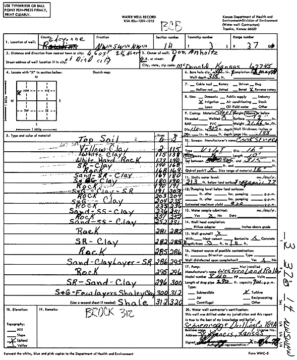
Specific Water Well Detail |
|
|
| Location Info | |||
| Owner: Anholtz, Don | Status: Constructed | ||
| Location: T3S, R37W, Sec. 14, NW SW NW | County: Cheyenne | ||
| Directions: from Bird City, 4 mi E and 2.5 mi N | |||
| Latitude: 39.795855 | Longitude: -101.4460088 | Datum NAD 27 | |
| Latitude: 39.7958512 | Longitude: -101.4464505 | Datum NAD 83 | |
| Longitude and latitude calculated by Survey from township-range-section-quarter calls. Only good to within the quarter call accuracy. | |||
| View well on interactive map | |||
| General Info | ||
| Well Depth: 315 ft. | Elevation: ft. | |
| Static Water Level: 213 ft. | Est. Yield: 900 gpm. | |
| Comp. Date: 02-May-1978 | Well Use: Irrigation | |
| DWR Applic. #: | Other ID: | |
| Links | |
| View info from Wizard Water Level Data base... | |
| View info from WIMAS Water Right Data base... | |
| Driller Info | ||
| Driller: Schoenrogge Drilling, Inc. | License #: 184 | |
| Scanned Form | View scan |
|
Chemical Sample Submitted?: No
Water Well disinfected?: | ||
| Ground water encountered: 0 ft. , 0 ft. , 0 ft. | ||
| Pump test data: Well water was 0 ft after 0 hours pumping 0 gpm | ||
| Casing Info | ||
| Casing Type:
Casing Joints: |
Diam: 0 in. to 0 ft
Diam: 0 in. to 0 ft Diam: 0 in. to 0 ft | |
| Casing height above land surface: in
Casing Weight: lbs/ft Wall thickness or gauge no.: | ||
| Screen and Perforation Info | ||
| Screen Type: | Screen Openings: | |
| Screen-perforated intervals | From: 305 ft to 315 ft
From: 0 ft to 0 ft From: 0 ft to 0 ft | |
| Gravel pack intervals | From: ft to ft | |
| Grout Info | ||
| Grout used: | From: 0 to 0 ft
From: 0 to 0 ft From: 0 to 0 ft | |
| Source of Possible Contamination | ||
| Source: | ||
| Direction from well: | Distance: 0 ft | |
| Lithologic Log
(Log data entered by KGS.) | ||
| From: 0 ft. to 2 ft. | Top soil | |
| From: 2 ft. to 115 ft. | Yellow clay | |
| From: 115 ft. to 138 ft. | White clay | |
| From: 138 ft. to 140 ft. | White hard rock | |
| From: 140 ft. to 168 ft. | Sand rock, clay | |
| From: 168 ft. to 169 ft. | Rock | |
| From: 169 ft. to 180 ft. | Sand, sand rock, clay | |
| From: 180 ft. to 190 ft. | Sand and gravel, clay | |
| From: 190 ft. to 191 ft. | Rock | |
| From: 191 ft. to 203 ft. | Sand and gravel, clay, sand rock | |
| From: 203 ft. to 204 ft. | Rock | |
| From: 204 ft. to 235 ft. | Sand and gravel, clay | |
| From: 235 ft. to 236 ft. | Rock | |
| From: 236 ft. to 251 ft. | Sand, sandstone, clay | |
| From: 251 ft. to 252 ft. | Rock | |
| From: 252 ft. to 281 ft. | Sand, sandstone, clay | |
| From: 281 ft. to 282 ft. | Rock | |
| From: 282 ft. to 285 ft. | Sandrock, clay | |
| From: 285 ft. to 286 ft. | Rock | |
| From: 286 ft. to 295 ft. | Sand, clay layer, sand rock | |
| From: 295 ft. to 296 ft. | Rock | |
| From: 296 ft. to 300 ft. | Sandrock, sand, clay | |
| From: 300 ft. to 312 ft. | Sand and gravel, few layers of shaley clay | |
| From: 312 ft. to 320 ft. | Shale | |