|
|
|
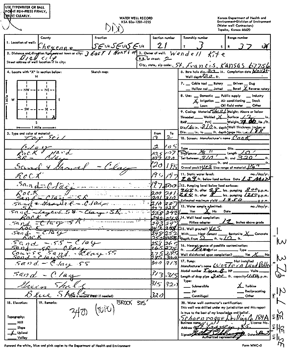
Specific Water Well Detail |
|
|
| Location Info | |||
| Owner: Kite, Wendell | Status: Constructed | ||
| Location: T3S, R37W, Sec. 21, SE SE SE | County: Cheyenne | ||
| Directions: from Bird City, 3 mi E and 1 mi N | |||
| Latitude: 39.7721929 | Longitude: -101.4674039 | Datum NAD 27 | |
| Latitude: 39.7721889 | Longitude: -101.467846 | Datum NAD 83 | |
| Longitude and latitude calculated by Survey from township-range-section-quarter calls. Only good to within the quarter call accuracy. | |||
| View well on interactive map | |||
| General Info | ||
| Well Depth: 320 ft. | Elevation: ft. | |
| Static Water Level: 209 ft. | Est. Yield: 1250 gpm. | |
| Comp. Date: 20-Nov-1975 | Well Use: Irrigation | |
| DWR Applic. #: | Other ID: | |
| Links | |
| View info from Wizard Water Level Data base... | |
| View info from WIMAS Water Right Data base... | |
| Driller Info | ||
| Driller: Schoenrogge Drilling, Inc. | License #: 184 | |
| Scanned Form | View scan |
|
Chemical Sample Submitted?: No
Water Well disinfected?: No | ||
| Ground water encountered: 0 ft. , 0 ft. , 0 ft. | ||
| Pump test data: Well water was 268 ft after 28 hours pumping 800 gpm Well water was 264 ft after 8 hours pumping 1250 gpm | ||
| Bore hole diameter: 30 inches to 320 ft | ||
| Casing Info | ||
| Casing Type: Steel
Casing Joints: Welded |
Diam: 16 in. to 310 ft
Diam: 0 in. to 0 ft Diam: 0 in. to 0 ft | |
| Casing height above land surface: 12 in
Casing Weight: 71.06 lbs/ft Wall thickness or gauge no.: .188 | ||
| Screen and Perforation Info | ||
| Screen Type: | Screen Openings: | |
| Screen-perforated intervals | From: 310 ft to 320 ft
From: 0 ft to 0 ft From: 0 ft to 0 ft | |
| Gravel pack intervals | From: ft to ft | |
| Grout Info | ||
| Grout used: Concrete | From: 0 to 10 ft
From: 0 to 0 ft From: 0 to 0 ft | |
| Source of Possible Contamination | ||
| Source: | ||
| Direction from well: | Distance: 0 ft | |
| Lithologic Log
(Log data entered by KGS.) | ||
| From: 0 ft. to 2 ft. | Topsoil | |
| From: 2 ft. to 105 ft. | Clay | |
| From: 105 ft. to 107 ft. | Rock hard | |
| From: 107 ft. to 120 ft. | Sand rock, clay | |
| From: 120 ft. to 195 ft. | Sand and gravel, clay | |
| From: 195 ft. to 197 ft. | Rock | |
| From: 197 ft. to 200 ft. | Sand, clay | |
| From: 200 ft. to 201 ft. | Rock | |
| From: 201 ft. to 210 ft. | Sand, clay, sand rock | |
| From: 210 ft. to 227 ft. | Sand and gravel, clay | |
| From: 227 ft. to 228 ft. | Sand rock | |
| From: 228 ft. to 242 ft. | Sand, layers sand rock, clay, sand rock | |
| From: 242 ft. to 243 ft. | Rock | |
| From: 243 ft. to 247 ft. | Sand, clay, sand rock | |
| From: 247 ft. to 248 ft. | Rock | |
| From: 248 ft. to 252 ft. | Sand, clay | |
| From: 252 ft. to 253 ft. | Rock | |
| From: 253 ft. to 265 ft. | Sand, sandstone, clay | |
| From: 265 ft. to 275 ft. | Sand, sand rock, clay | |
| From: 275 ft. to 285 ft. | Coarse sand, clay, sandstone | |
| From: 285 ft. to 300 ft. | Sand, clay, sandstone | |
| From: 300 ft. to 313 ft. | Sand, clay, sandstone | |
| From: 313 ft. to 315 ft. | Sand, clay | |
| From: 315 ft. to 320 ft. | Green shale | |
| From: 320 ft. to ft. | Blue shale | |