|
|
|
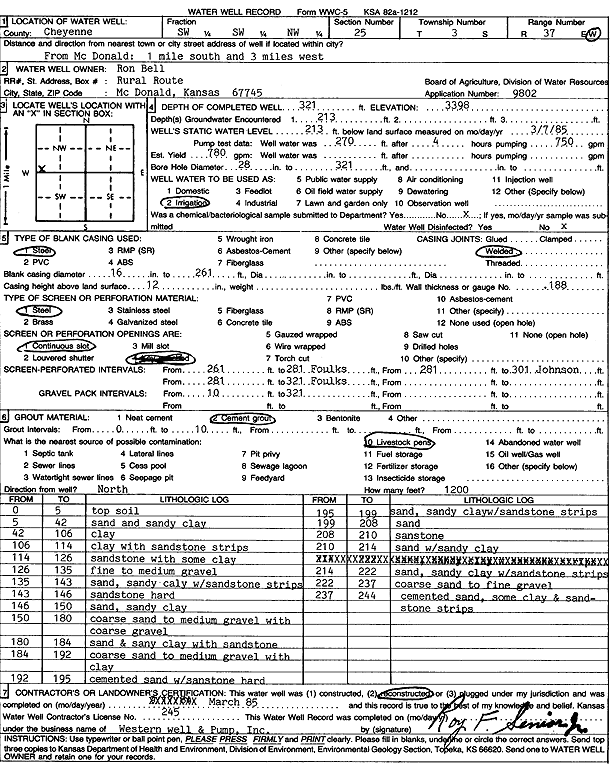
Specific Water Well Detail |
|
|
| Location Info | |||
| Owner: Bell, Ron | Status: Reconstructed | ||
| Location: T3S, R37W, Sec. 25, SW SW NW | County: Cheyenne | ||
| Directions: from McDonald, 1 mi S and 3 mi W | |||
| Latitude: 39.7649981 | Longitude: -101.4274473 | Datum NAD 27 | |
| Latitude: 39.7649945 | Longitude: -101.4278886 | Datum NAD 83 | |
| Longitude and latitude calculated by Survey from township-range-section-quarter calls. Only good to within the quarter call accuracy. | |||
| View well on interactive map | |||
| General Info | ||
| Well Depth: 321 ft. | Elevation: 3398 ft. | |
| Static Water Level: 213 ft. | Est. Yield: 780 gpm. | |
| Comp. Date: 01-Mar-1985 | Well Use: Irrigation | |
| DWR Applic. #: 9802 | Other ID: | |
| Links | |
| No Wizard information available. | |
| View info from WIMAS Water Right Data base... | |
| Driller Info | ||
| Driller: Western Well & Pump, Inc. | License #: 245 | |
| Scanned Form | View scan |
|
Chemical Sample Submitted?: No
Water Well disinfected?: | ||
| Ground water encountered: 213 ft. , 0 ft. , 0 ft. | ||
| Pump test data: Well water was 270 ft after 4 hours pumping 750 gpm | ||
| Casing Info | ||
| Casing Type: Steel
Casing Joints: |
Diam: 16 in. to 261 ft
Diam: 0 in. to 0 ft Diam: 0 in. to 0 ft | |
| Casing height above land surface: in
Casing Weight: lbs/ft Wall thickness or gauge no.: | ||
| Screen and Perforation Info | ||
| Screen Type: Steel | Screen Openings: Continuous slot | |
| Screen-perforated intervals | From: 261 ft to 281 ft
From: 281 ft to 301 ft From: 281 ft to 321 ft | |
| Gravel pack intervals | From: ft to ft | |
| Grout Info | ||
| Grout used: Cement grout | From: 0 to 10 ft
From: 0 to 0 ft From: 0 to 0 ft | |
| Source of Possible Contamination | ||
| Source: Livestock pens | ||
| Direction from well: | Distance: 0 ft | |
| Lithologic Log
(Log data entered by KGS.) | ||
| From: 0 ft. to 5 ft. | top soil | |
| From: 5 ft. to 42 ft. | sand and sandy clay | |
| From: 42 ft. to 106 ft. | clay | |
| From: 106 ft. to 114 ft. | clay with sandstone strips | |
| From: 114 ft. to 126 ft. | sandstone with some clay | |
| From: 126 ft. to 135 ft. | fine to medium gravel | |
| From: 135 ft. to 143 ft. | sand, sandy clay, with sandstone strips | |
| From: 143 ft. to 146 ft. | sandstone, hard | |
| From: 146 ft. to 150 ft. | sand, sandy clay | |
| From: 150 ft. to 180 ft. | coarse sand to medium gravel with coarse gravel | |
| From: 180 ft. to 184 ft. | sand and sandy clay with sandstone | |
| From: 184 ft. to 192 ft. | coarse sand to medium gravel with clay | |
| From: 192 ft. to 195 ft. | cemented sand with sandstone, hard | |
| From: 195 ft. to 199 ft. | sand, sandy clay, and sandstone strips | |
| From: 199 ft. to 208 ft. | sand | |
| From: 208 ft. to 210 ft. | sandstone | |
| From: 210 ft. to 214 ft. | sand with sandy clay | |
| From: 214 ft. to 222 ft. | sand, sandy clay, with sandstone strips | |
| From: 222 ft. to 237 ft. | coarse sand to fine gravel | |
| From: 237 ft. to 244 ft. | cemented sand, some clay, and sandstone strips | |