|
|
|
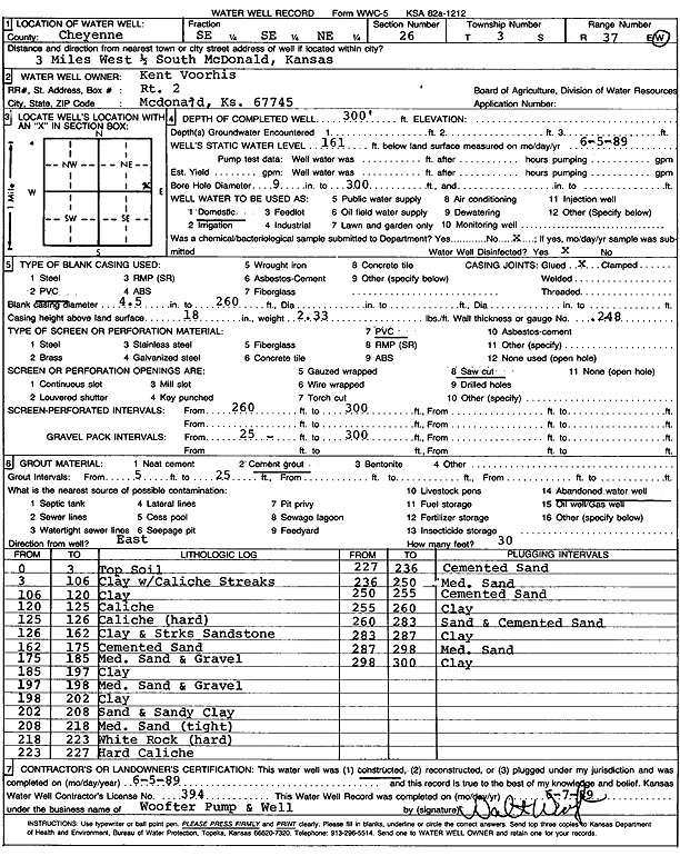
Specific Water Well Detail |
|
|
| Location Info | |||
| Owner: Voorhies, Kent | Status: Constructed | ||
| Location: T3S, R37W, Sec. 26, SE SE NE | County: Cheyenne | ||
| Directions: from McDonald, 3 mi W and 0.5 mi S | |||
| Latitude: 39.7649999 | Longitude: -101.4298002 | Datum NAD 27 | |
| Latitude: 39.7649963 | Longitude: -101.4302415 | Datum NAD 83 | |
| Longitude and latitude calculated by Survey from township-range-section-quarter calls. Only good to within the quarter call accuracy. | |||
| View well on interactive map | |||
| General Info | ||
| Well Depth: 300 ft. | Elevation: ft. | |
| Static Water Level: 161 ft. | Est. Yield: gpm. | |
| Comp. Date: 05-Jun-1989 | Well Use: Domestic | |
| DWR Applic. #: | Other ID: | |
| Driller Info | ||
| Driller: Walter Woofter Pump & Well | License #: 394 | |
| Scanned Form | View scan |
|
Chemical Sample Submitted?: No
Water Well disinfected?: | ||
| Ground water encountered: 0 ft. , 0 ft. , 0 ft. | ||
| Pump test data: Well water was 0 ft after 0 hours pumping 0 gpm | ||
| Casing Info | ||
| Casing Type: PVC
Casing Joints: |
Diam: 4 in. to 260 ft
Diam: 0 in. to 0 ft Diam: 0 in. to 0 ft | |
| Casing height above land surface: in
Casing Weight: lbs/ft Wall thickness or gauge no.: | ||
| Screen and Perforation Info | ||
| Screen Type: PVC | Screen Openings: Saw cut | |
| Screen-perforated intervals | From: 260 ft to 300 ft
From: 0 ft to 0 ft From: 0 ft to 0 ft | |
| Gravel pack intervals | From: ft to ft | |
| Grout Info | ||
| Grout used: Cement grout | From: 5 to 25 ft
From: 0 to 0 ft From: 0 to 0 ft | |
| Source of Possible Contamination | ||
| Source: Abandoned water well | ||
| Direction from well: | Distance: 0 ft | |
| Lithologic Log
(Log data entered by KGS.) | ||
| From: 0 ft. to 3 ft. | Topsoil | |
| From: 3 ft. to 106 ft. | Clay with caliche streaks | |
| From: 106 ft. to 120 ft. | Clay | |
| From: 120 ft. to 125 ft. | Caliche | |
| From: 125 ft. to 126 ft. | Caliche (hard) | |
| From: 126 ft. to 162 ft. | Clay and streaks sandstone | |
| From: 162 ft. to 175 ft. | Cemented sand | |
| From: 175 ft. to 185 ft. | Medium sand and gravel | |
| From: 185 ft. to 197 ft. | Clay | |
| From: 197 ft. to 198 ft. | Medium sand and gravel | |
| From: 198 ft. to 202 ft. | Clay | |
| From: 202 ft. to 208 ft. | Sand and sandy clay | |
| From: 208 ft. to 218 ft. | Medium sand (tight) | |
| From: 218 ft. to 223 ft. | White rock (hard) | |
| From: 223 ft. to 227 ft. | Hard caliche | |
| From: 227 ft. to 236 ft. | Cemented sand | |
| From: 236 ft. to 250 ft. | Medium sand | |
| From: 250 ft. to 255 ft. | Cemented sand | |
| From: 255 ft. to 260 ft. | Clay | |
| From: 260 ft. to 283 ft. | Sand and cemented sand | |
| From: 283 ft. to 287 ft. | Clay | |
| From: 287 ft. to 298 ft. | Medium sand | |
| From: 298 ft. to 300 ft. | Clay | |