|
|
|
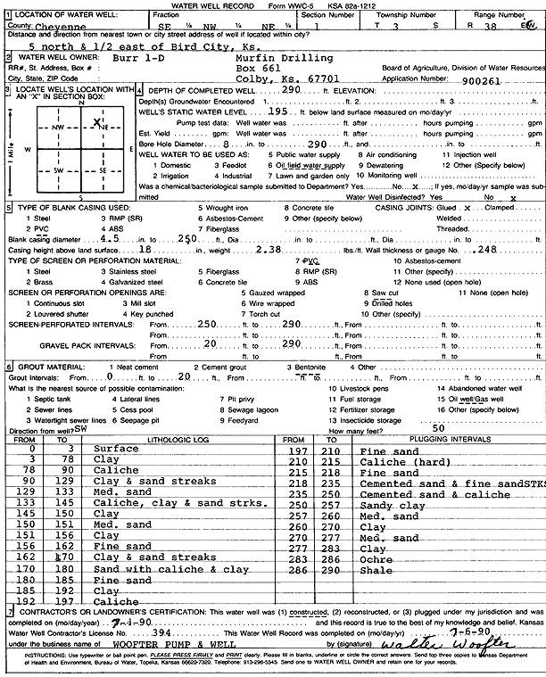
Specific Water Well Detail |
|
|
| Location Info | |||
| Owner: Murfin Drilling Co. | Status: Constructed | ||
| Location: T3S, R38W, Sec. 1, SE NW NE | County: Cheyenne | ||
| Directions: from Bird City, 5 mi N and 0.5 mi E | |||
| Latitude: 39.8266465 | Longitude: -101.5277505 | Datum NAD 27 | |
| Latitude: 39.8266419 | Longitude: -101.5281943 | Datum NAD 83 | |
| Longitude and latitude calculated by Survey from township-range-section-quarter calls. Only good to within the quarter call accuracy. | |||
| View well on interactive map | |||
| General Info | ||
| Well Depth: 290 ft. | Elevation: ft. | |
| Static Water Level: 195 ft. | Est. Yield: gpm. | |
| Comp. Date: 04-Jul-1990 | Well Use: Oil Field Water Supply | |
| DWR Applic. #: 900261 | Other ID: Burr D-1 | |
| Links | |
| No Wizard information available. | |
| View info from WIMAS Water Right Data base... | |
| Driller Info | ||
| Driller: Walter Woofter Pump & Well | License #: 394 | |
| Scanned Form | View scan |
|
Chemical Sample Submitted?: No
Water Well disinfected?: | ||
| Ground water encountered: 0 ft. , 0 ft. , 0 ft. | ||
| Pump test data: Well water was 0 ft after 0 hours pumping 0 gpm | ||
| Casing Info | ||
| Casing Type: PVC
Casing Joints: |
Diam: 4 in. to 240 ft
Diam: 0 in. to 0 ft Diam: 0 in. to 0 ft | |
| Casing height above land surface: in
Casing Weight: lbs/ft Wall thickness or gauge no.: | ||
| Screen and Perforation Info | ||
| Screen Type: PVC | Screen Openings: Saw cut | |
| Screen-perforated intervals | From: 240 ft to 290 ft
From: 0 ft to 0 ft From: 0 ft to 0 ft | |
| Gravel pack intervals | From: ft to ft | |
| Grout Info | ||
| Grout used: Bentonite | From: 0 to 20 ft
From: 0 to 0 ft From: 0 to 0 ft | |
| Source of Possible Contamination | ||
| Source: Oil well/gas well | ||
| Direction from well: | Distance: 0 ft | |
| Lithologic Log
(Log data entered by KGS.) | ||
| From: 0 ft. to 3 ft. | Surface | |
| From: 3 ft. to 78 ft. | Clay | |
| From: 78 ft. to 90 ft. | Caliche | |
| From: 90 ft. to 129 ft. | Clay and sand streaks | |
| From: 129 ft. to 133 ft. | Medium sand | |
| From: 133 ft. to 145 ft. | Caliche, clay and sand streaks | |
| From: 145 ft. to 150 ft. | Clay | |
| From: 150 ft. to 151 ft. | Medium sand | |
| From: 151 ft. to 156 ft. | Clay | |
| From: 156 ft. to 162 ft. | Fine sand | |
| From: 162 ft. to 170 ft. | Clay and sand streaks | |
| From: 170 ft. to 180 ft. | Sand with caliche and clay | |
| From: 180 ft. to 185 ft. | Fine sand | |
| From: 185 ft. to 192 ft. | Clay | |
| From: 192 ft. to 197 ft. | Caliche | |
| From: 197 ft. to 210 ft. | Fine sand | |
| From: 210 ft. to 215 ft. | Caliche (hard) | |
| From: 215 ft. to 218 ft. | Fine sand | |
| From: 218 ft. to 235 ft. | Cemented sand and fine sand streaks | |
| From: 235 ft. to 250 ft. | Cemented sand and caliche | |
| From: 250 ft. to 257 ft. | Sandy clay | |
| From: 257 ft. to 260 ft. | Medium sand | |
| From: 260 ft. to 270 ft. | Clay | |
| From: 270 ft. to 277 ft. | Medium sand | |
| From: 277 ft. to 283 ft. | Clay | |
| From: 283 ft. to 286 ft. | Ochre | |
| From: 286 ft. to 290 ft. | Shale | |