|
|
|
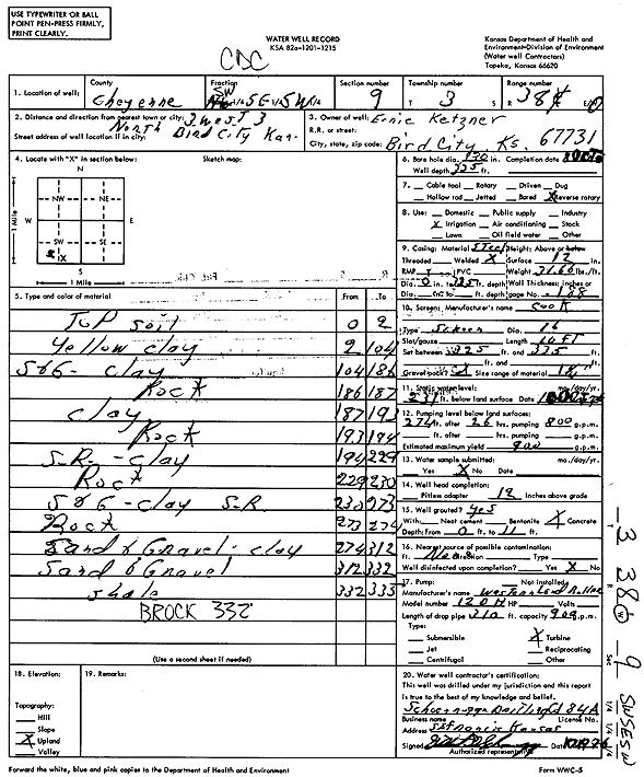
Specific Water Well Detail |
|
|
| Location Info | |||
| Owner: Ketzner, Ernie | Status: Constructed | ||
| Location: T3S, R38W, Sec. 9, SW SE SW | County: Cheyenne | ||
| Directions: from Bird City, 3 mi W and 3 mi N | |||
| Latitude: 39.8012825 | Longitude: -101.5917269 | Datum NAD 27 | |
| Latitude: 39.8012772 | Longitude: -101.5921726 | Datum NAD 83 | |
| Longitude and latitude calculated by Survey from township-range-section-quarter calls. Only good to within the quarter call accuracy. | |||
| View well on interactive map | |||
| General Info | ||
| Well Depth: 335 ft. | Elevation: ft. | |
| Static Water Level: 231 ft. | Est. Yield: 900 gpm. | |
| Comp. Date: 08-Oct-1976 | Well Use: Irrigation | |
| DWR Applic. #: | Other ID: | |
| Links | |
| View info from Wizard Water Level Data base... | |
| View info from WIMAS Water Right Data base... | |
| Driller Info | ||
| Driller: Schoenrogge Drilling, Inc. | License #: 184 | |
| Scanned Form | View scan |
|
Chemical Sample Submitted?: No
Water Well disinfected?: | ||
| Ground water encountered: 0 ft. , 0 ft. , 0 ft. | ||
| Pump test data: Well water was 0 ft after 0 hours pumping 0 gpm | ||
| Casing Info | ||
| Casing Type:
Casing Joints: |
Diam: 0 in. to 0 ft
Diam: 0 in. to 0 ft Diam: 0 in. to 0 ft | |
| Casing height above land surface: in
Casing Weight: lbs/ft Wall thickness or gauge no.: | ||
| Screen and Perforation Info | ||
| Screen Type: | Screen Openings: | |
| Screen-perforated intervals | From: 325 ft to 335 ft
From: 0 ft to 0 ft From: 0 ft to 0 ft | |
| Gravel pack intervals | From: ft to ft | |
| Grout Info | ||
| Grout used: | From: 0 to 0 ft
From: 0 to 0 ft From: 0 to 0 ft | |
| Source of Possible Contamination | ||
| Source: | ||
| Direction from well: | Distance: 0 ft | |
| Lithologic Log
(Log data entered by KGS.) | ||
| From: 0 ft. to 2 ft. | Top soil | |
| From: 2 ft. to 104 ft. | Yellow clay | |
| From: 104 ft. to 186 ft. | Sand and gravel, clay | |
| From: 186 ft. to 187 ft. | Rock | |
| From: 187 ft. to 193 ft. | Clay | |
| From: 193 ft. to 194 ft. | Rock | |
| From: 194 ft. to 229 ft. | Sand rock, clay | |
| From: 229 ft. to 230 ft. | Rock | |
| From: 230 ft. to 273 ft. | Sand and gravel, clay, sand rock | |
| From: 273 ft. to 274 ft. | Rock | |
| From: 274 ft. to 312 ft. | Sand and gravel, clay | |
| From: 312 ft. to 332 ft. | Sand and gravel | |
| From: 332 ft. to 335 ft. | Shale | |