|
|
|
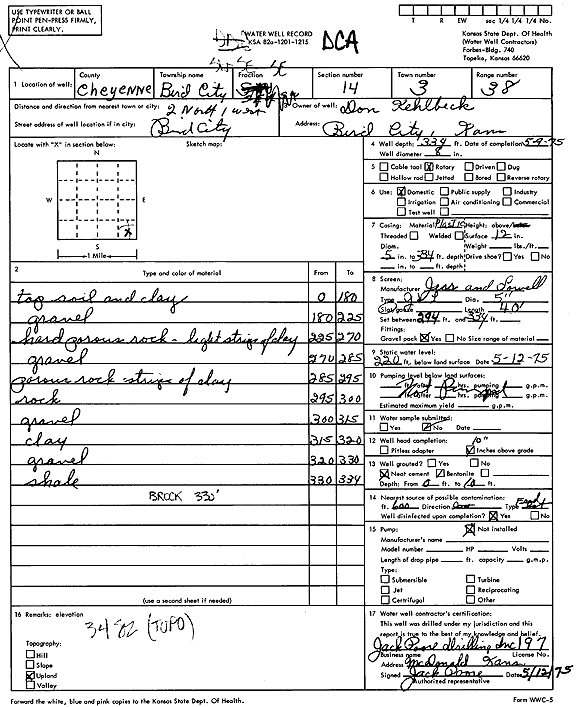
Specific Water Well Detail |
|
|
| Location Info | |||
| Owner: Kehlbeck, Don | Status: Constructed | ||
| Location: T3S, R38W, Sec. 14, SW SE SE | County: Cheyenne | ||
| Directions: from Bird City, 2 mi N and 1 mi W | |||
| Latitude: 39.7868259 | Longitude: -101.544916 | Datum NAD 27 | |
| Latitude: 39.7868212 | Longitude: -101.5453603 | Datum NAD 83 | |
| Longitude and latitude calculated by Survey from township-range-section-quarter calls. Only good to within the quarter call accuracy. | |||
| View well on interactive map | |||
| General Info | ||
| Well Depth: 334 ft. | Elevation: ft. | |
| Static Water Level: 220 ft. | Est. Yield: gpm. | |
| Comp. Date: 09-May-1975 | Well Use: Domestic | |
| DWR Applic. #: | Other ID: | |
| Driller Info | ||
| Driller: Jack Poore Drilling Inc. | License #: 197 | |
| Scanned Form | View scan |
|
Chemical Sample Submitted?: No
Water Well disinfected?: | ||
| Ground water encountered: 0 ft. , 0 ft. , 0 ft. | ||
| Pump test data: Well water was 0 ft after 0 hours pumping 0 gpm | ||
| Casing Info | ||
| Casing Type:
Casing Joints: |
Diam: 0 in. to 0 ft
Diam: 0 in. to 0 ft Diam: 0 in. to 0 ft | |
| Casing height above land surface: in
Casing Weight: lbs/ft Wall thickness or gauge no.: | ||
| Screen and Perforation Info | ||
| Screen Type: | Screen Openings: | |
| Screen-perforated intervals | From: 294 ft to 334 ft
From: 0 ft to 0 ft From: 0 ft to 0 ft | |
| Gravel pack intervals | From: ft to ft | |
| Grout Info | ||
| Grout used: | From: 0 to 0 ft
From: 0 to 0 ft From: 0 to 0 ft | |
| Source of Possible Contamination | ||
| Source: | ||
| Direction from well: | Distance: 0 ft | |
| Lithologic Log
(Log data entered by KGS.) | ||
| From: 0 ft. to 180 ft. | Topsoil and clay | |
| From: 180 ft. to 225 ft. | Gravel | |
| From: 225 ft. to 270 ft. | Hard porous rock, light streaks of clay | |
| From: 270 ft. to 285 ft. | Gravel | |
| From: 285 ft. to 295 ft. | Porous rock streaks of clay | |
| From: 295 ft. to 300 ft. | Rock | |
| From: 300 ft. to 315 ft. | Gravel | |
| From: 315 ft. to 320 ft. | Clay | |
| From: 320 ft. to 330 ft. | Gravel | |
| From: 330 ft. to 334 ft. | Shale | |