|
|
|
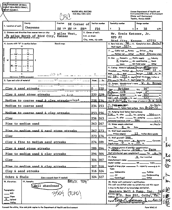
Specific Water Well Detail |
|
|
| Location Info | |||
| Owner: Ketzner, Ernie, Jr. | Status: Constructed | ||
| Location: T3S, R38W, Sec. 16, SE SW NW SW | County: Cheyenne | ||
| Directions: from Bird City, 3 mi W and 3.5 mi N | |||
| Latitude: 39.7899742 | Longitude: -101.5960523 | Datum NAD 27 | |
| Latitude: 39.7899689 | Longitude: -101.5964981 | Datum NAD 83 | |
| Longitude and latitude calculated by Survey from township-range-section-quarter calls. Only good to within the quarter call accuracy. | |||
| View well on interactive map | |||
| General Info | ||
| Well Depth: 327 ft. | Elevation: ft. | |
| Static Water Level: 212 ft. | Est. Yield: 394 gpm. | |
| Comp. Date: 02-Aug-1975 | Well Use: Irrigation | |
| DWR Applic. #: | Other ID: | |
| Driller Info | ||
| Driller: Western Well & Pump, Inc. | License #: 245 | |
| Scanned Form | View scan |
|
Chemical Sample Submitted?: No
Water Well disinfected?: | ||
| Ground water encountered: 0 ft. , 0 ft. , 0 ft. | ||
| Pump test data: Well water was 0 ft after 0 hours pumping 0 gpm | ||
| Casing Info | ||
| Casing Type:
Casing Joints: |
Diam: 0 in. to 0 ft
Diam: 0 in. to 0 ft Diam: 0 in. to 0 ft | |
| Casing height above land surface: in
Casing Weight: lbs/ft Wall thickness or gauge no.: | ||
| Screen and Perforation Info | ||
| Screen Type: | Screen Openings: | |
| Screen-perforated intervals | From: 237 ft to 317 ft
From: 0 ft to 0 ft From: 0 ft to 0 ft | |
| Gravel pack intervals | From: ft to ft | |
| Grout Info | ||
| Grout used: | From: 0 to 0 ft
From: 0 to 0 ft From: 0 to 0 ft | |
| Source of Possible Contamination | ||
| Source: | ||
| Direction from well: | Distance: 0 ft | |
| Lithologic Log
(Log data entered by KGS.) | ||
| From: 0 ft. to 220 ft. | Clay and sand streaks | |
| From: 220 ft. to 228 ft. | Clay and sandstone streaks | |
| From: 228 ft. to 234 ft. | Medium to coarse sand and clay streaks | |
| From: 234 ft. to 253 ft. | Medium to coarse sand | |
| From: 253 ft. to 256 ft. | Medium to coarse sand and clay streaks | |
| From: 256 ft. to 263 ft. | Clay | |
| From: 263 ft. to 267 ft. | Fine to medium sand | |
| From: 267 ft. to 273 ft. | Fine to medium sand and stone streaks | |
| From: 273 ft. to 274 ft. | Clay | |
| From: 274 ft. to 289 ft. | Clay and fine to medium sand streaks | |
| From: 289 ft. to 294 ft. | Clay and sandstone streaks | |
| From: 294 ft. to 304 ft. | Fine to medium sand and clay streaks | |
| From: 304 ft. to 307 ft. | Clay | |
| From: 307 ft. to 316 ft. | Fine to medium sand and clay streaks | |
| From: 316 ft. to 324 ft. | Clay and sand streaks | |
| From: 324 ft. to 327 ft. | Ochre and shale | |