|
|
|
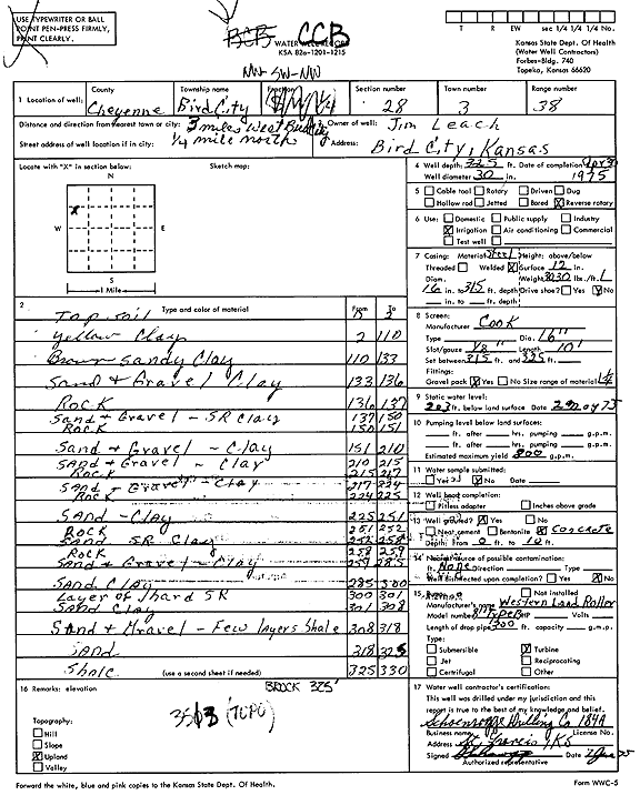
Specific Water Well Detail |
|
|
| Location Info | |||
| Owner: Leach, Jim | Status: Constructed | ||
| Location: T3S, R38W, Sec. 28, NW SW NW | County: Cheyenne | ||
| Directions: from Bird City, 3 mi W and 0.25 mi N | |||
| Latitude: 39.7668408 | Longitude: -101.5969452 | Datum NAD 27 | |
| Latitude: 39.7668355 | Longitude: -101.597391 | Datum NAD 83 | |
| Longitude and latitude calculated by Survey from township-range-section-quarter calls. Only good to within the quarter call accuracy. | |||
| View well on interactive map | |||
| General Info | ||
| Well Depth: 325 ft. | Elevation: ft. | |
| Static Water Level: 203 ft. | Est. Yield: 800 gpm. | |
| Comp. Date: 30-Apr-1975 | Well Use: Irrigation | |
| DWR Applic. #: | Other ID: | |
| Links | |
| View info from Wizard Water Level Data base... | |
| View info from WIMAS Water Right Data base... | |
| Driller Info | ||
| Driller: Schoenrogge Drilling, Inc. | License #: 184 | |
| Scanned Form | View scan |
|
Chemical Sample Submitted?: No
Water Well disinfected?: | ||
| Ground water encountered: 0 ft. , 0 ft. , 0 ft. | ||
| Pump test data: Well water was 0 ft after 0 hours pumping 0 gpm | ||
| Casing Info | ||
| Casing Type:
Casing Joints: |
Diam: 0 in. to 0 ft
Diam: 0 in. to 0 ft Diam: 0 in. to 0 ft | |
| Casing height above land surface: in
Casing Weight: lbs/ft Wall thickness or gauge no.: | ||
| Screen and Perforation Info | ||
| Screen Type: | Screen Openings: | |
| Screen-perforated intervals | From: 315 ft to 325 ft
From: 0 ft to 0 ft From: 0 ft to 0 ft | |
| Gravel pack intervals | From: ft to ft | |
| Grout Info | ||
| Grout used: | From: 0 to 0 ft
From: 0 to 0 ft From: 0 to 0 ft | |
| Source of Possible Contamination | ||
| Source: | ||
| Direction from well: | Distance: 0 ft | |
| Lithologic Log
(Log data entered by KGS.) | ||
| From: 0 ft. to 2 ft. | Topsoil | |
| From: 2 ft. to 110 ft. | Yellow clay | |
| From: 110 ft. to 133 ft. | Brown sandy clay | |
| From: 133 ft. to 136 ft. | Sand and gravel, clay | |
| From: 136 ft. to 137 ft. | Rock | |
| From: 137 ft. to 150 ft. | Sand and gravel, sand rock, clay | |
| From: 150 ft. to 151 ft. | Rock | |
| From: 151 ft. to 210 ft. | Sand and gravel, clay | |
| From: 210 ft. to 215 ft. | Sand and gravel, clay | |
| From: 215 ft. to 217 ft. | Rock | |
| From: 217 ft. to 224 ft. | Sand and gravel, clay | |
| From: 224 ft. to 225 ft. | Rock | |
| From: 225 ft. to 251 ft. | Sand, clay | |
| From: 251 ft. to 252 ft. | Rock | |
| From: 252 ft. to 258 ft. | Sand, sand rock, clay | |
| From: 258 ft. to 259 ft. | Rock | |
| From: 259 ft. to 285 ft. | Sand and gravel, clay | |
| From: 285 ft. to 300 ft. | Sand, clay | |
| From: 300 ft. to 301 ft. | Layer of hard sand rock | |
| From: 301 ft. to 308 ft. | Sand, clay | |
| From: 308 ft. to 318 ft. | Sand and gravel, few layers shale | |
| From: 318 ft. to 325 ft. | Sand | |
| From: 325 ft. to 330 ft. | Shale | |